Barisey-au-Plain | |
|---|---|
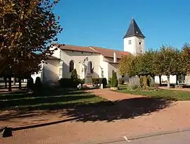 The church in Barisey-au-Plain | |
 Coat of arms | |
Location of Barisey-au-Plain | |
 Barisey-au-Plain  Barisey-au-Plain | |
| Coordinates: 48°31′33″N 5°50′41″E / 48.5258°N 5.8447°E | |
| Country | France |
| Region | Grand Est |
| Department | Meurthe-et-Moselle |
| Arrondissement | Toul |
| Canton | Meine au Saintois |
| Intercommunality | CC Pays de Colombey et Sud Toulois |
| Government | |
| • Mayor (2020–2026) | Jean-Marie Gerondi[1] |
| Area 1 | 10.85 km2 (4.19 sq mi) |
| Population | 393 |
| • Density | 36/km2 (94/sq mi) |
| Time zone | UTC+01:00 (CET) |
| • Summer (DST) | UTC+02:00 (CEST) |
| INSEE/Postal code | 54046 /54170 |
| Elevation | 274–332 m (899–1,089 ft) (avg. 279 m or 915 ft) |
| 1 French Land Register data, which excludes lakes, ponds, glaciers > 1 km2 (0.386 sq mi or 247 acres) and river estuaries. | |
Barisey-au-Plain (French pronunciation: [baʁizɛ o plɛ̃]) is a commune in the Meurthe-et-Moselle department in northeastern France.
Population
| Year | Pop. | ±% |
|---|---|---|
| 1968 | 274 | — |
| 1975 | 256 | −6.6% |
| 1982 | 317 | +23.8% |
| 1990 | 304 | −4.1% |
| 1999 | 329 | +8.2% |
| 2009 | 355 | +7.9% |
See also
References
- ↑ "Répertoire national des élus: les maires". data.gouv.fr, Plateforme ouverte des données publiques françaises (in French). 2 December 2020.
- ↑ "Populations légales 2021". The National Institute of Statistics and Economic Studies. 28 December 2023.
Wikimedia Commons has media related to Barisey-au-Plain.
This article is issued from Wikipedia. The text is licensed under Creative Commons - Attribution - Sharealike. Additional terms may apply for the media files.