Barruecopardo | |
|---|---|
 | |
 Seal | |
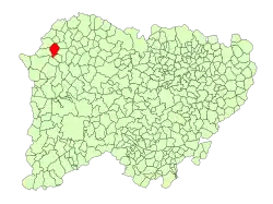 Location in Salamanca | |
 Barruecopardo Location in Spain | |
| Coordinates: 41°04′21″N 6°39′46″W / 41.07250°N 6.66278°W | |
| Country | Spain |
| Autonomous community | Castile and León |
| Province | Salamanca |
| Comarca | Vitigudino |
| Subcomarca | La Ramajería |
| Government | |
| • Mayor | Jesús María Ortiz Fernández (People's Party) |
| Area | |
| • Total | 38 km2 (15 sq mi) |
| Elevation | 730 m (2,400 ft) |
| Population (2018)[2] | |
| • Total | 442 |
| • Density | 12/km2 (30/sq mi) |
| Time zone | UTC+1 (CET) |
| • Summer (DST) | UTC+2 (CEST) |
| Postal code | 37255 |
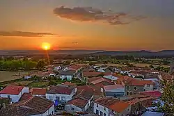
Barruecopardo is a village and municipality in the province of Salamanca, western Spain, part of the autonomous community of Castile-Leon. It has a population of 504 people and lies 730 metres (2,400 ft) above sea level.
The postal code is 37255. Barruecopardo mine is a tungsten mine in the vicinity.
References
- 1 2 "Municipio:Barruecopardo". www.lasalina.es. Retrieved 2017-10-25.
- ↑ Municipal Register of Spain 2018. National Statistics Institute.
This article is issued from Wikipedia. The text is licensed under Creative Commons - Attribution - Sharealike. Additional terms may apply for the media files.