Calvarrasa de Abajo | |
|---|---|
 | |
 Flag  Coat of arms | |
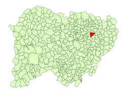 Location of Calvarrasa de Abajo in the province of Salamanca | |
 Calvarrasa de Abajo | |
| Coordinates: 40°57′N 5°33′W / 40.950°N 5.550°W | |
| Country | Spain |
| Autonomous community | Castile and León |
| Province | Salamanca |
| Comarca | Campo de Salamanca |
| Government | |
| • Mayor | Marcelino Mateos Hernández (People's Party) |
| Area | |
| • Total | 28 km2 (11 sq mi) |
| Elevation | 785 m (2,575 ft) |
| Population (2018)[2] | |
| • Total | 1,152 |
| • Density | 41/km2 (110/sq mi) |
| Time zone | UTC+1 (CET) |
| • Summer (DST) | UTC+2 (CEST) |
| Postal Code | 37181 |
| Website | www |
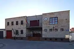
Calvarrasa de Abajo is a village and municipality in the province of Salamanca, western Spain, part of the autonomous community of Castile-Leon. It is 10 kilometres (6.2 mi) from the provincial capital city of Salamanca and has a population of 1,143 people.[3] The municipality covers an area of 28 km2 (11 sq mi).
It lies 785 metres (2,575 ft) above sea level and the postal code is 37181.
References
- 1 2 "Municipio:Calvarrasa de Abajo". www.lasalina.es (in Spanish). Retrieved 2017-11-07.
- ↑ Municipal Register of Spain 2018. National Statistics Institute.
- ↑ "Salamanca: Población por municipios y sexo". www.ine.es (in Spanish). Retrieved 2017-11-07.
This article is issued from Wikipedia. The text is licensed under Creative Commons - Attribution - Sharealike. Additional terms may apply for the media files.