Beroroha | |
|---|---|
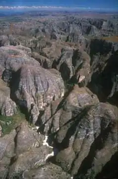 The Makay Massif | |
| Country | |
| Region | Atsimo-Andrefana |
| Postal code | 611 |
Beroroha is a district of Atsimo-Andrefana in Madagascar.[1][2]
Roads
Beroroha lies on the Mangoky river. The road to Beroroha (National road 15) is unpaved and can only be taken by 4x4 pick-ups.
Municipalities
The district is further divided into nine municipalities:
- Behisatra (Behisatsy)
- Bemavo
- Beroroha
- Fanjakana
- Mandronarivo
- Marerano
- Sakena
- Tanamary
- Tanandava
Tourist sights
The Makay Massif is situated in the district of Beroroha.[3]
References
- ↑ REPOBLIKAN’I MADAGASIKARA:Tanindrazana – Fahafahana – Fandrosoana (PDF). MINISTERE DE L’AGRICULTURE, DE L’ELEVAGE ET DE LA PECHE. October 2007. pp. 42–44. Archived from the original (PDF) on 2018-06-12. Retrieved 2018-06-09.
- ↑ "Madagascar: Administrative Division". citypopulation. Retrieved 10 June 2018.
- ↑ Beroroha
Capital: Toliara | ||
| Ampanihy Ouest (19) - 605 | 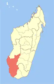 | |
| Ankazoabo - 606 - (10) |
| |
| Benenitra - 610 - (6) |
| |
| Beroroha - 611 - (9) |
| |
| Betioky-Atsimo -612 - (31) |
| |
| Morombe (9) - 618 | ||
| Sakaraha (12) - 620 | ||
| Toliara I (1) | ||
| Toliara II (22) (602) | ||
9 districts; 119 communes | ||
This article is issued from Wikipedia. The text is licensed under Creative Commons - Attribution - Sharealike. Additional terms may apply for the media files.