Canal San Bovo | |
|---|---|
| Comune di Canal San Bovo | |
 | |
 Coat of arms | |
Location of Canal San Bovo | |
 Canal San Bovo Location of Canal San Bovo in Italy 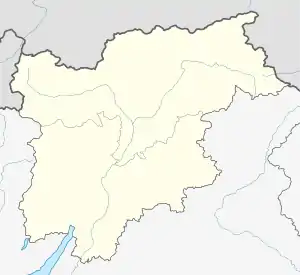 Canal San Bovo Canal San Bovo (Trentino-Alto Adige/Südtirol) | |
| Coordinates: 46°9′N 11°44′E / 46.150°N 11.733°E | |
| Country | Italy |
| Region | Trentino-Alto Adige/Südtirol |
| Province | Trentino (TN) |
| Frazioni | Caoria, Cicona, Gobbera, Prade, Ronco, Zortea |
| Government | |
| • Mayor | Bortolo Rattin |
| Area | |
| • Total | 125.5 km2 (48.5 sq mi) |
| Population (30 April 2020)[2] | |
| • Total | 1,448 |
| • Density | 12/km2 (30/sq mi) |
| Demonym | Canalini |
| Time zone | UTC+1 (CET) |
| • Summer (DST) | UTC+2 (CEST) |
| Postal code | 38050 |
| Dialing code | 0439 |
| Patron saint | St. Bartholomew the Apostle and St. Bovo |
| Saint day | 24 August |
| Website | http://www.canalsanbovo.net |
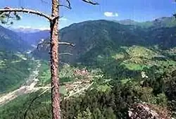
Canal San Bovo (Canal in local dialect) is a comune (municipality) in Trentino in the northern Italian Region Trentino-Alto Adige/Südtirol, located about 90 kilometres (56 mi) north-east of Trento. Canal San Bovo is a typical alpine village; from 1401 to 1918 it was a possession of the Austro-Hungarian Empire.
Twin towns
- Civitella Alfedena, Italy
References
- ↑ "Superficie di Comuni Province e Regioni italiane al 9 ottobre 2011". Italian National Institute of Statistics. Retrieved 16 March 2019.
- ↑ "Popolazione Residente al 1° Gennaio 2018". Italian National Institute of Statistics. Retrieved 16 March 2019.
This article is issued from Wikipedia. The text is licensed under Creative Commons - Attribution - Sharealike. Additional terms may apply for the media files.