Storo | |
|---|---|
| Comune di Storo | |
Location of Storo | |
 Storo Location of Storo in Italy 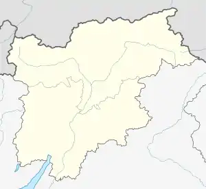 Storo Storo (Trentino-Alto Adige/Südtirol) | |
| Coordinates: 45°51′N 10°35′E / 45.850°N 10.583°E | |
| Country | Italy |
| Region | Trentino-Alto Adige/Südtirol |
| Province | Trentino (TN) |
| Frazioni | Darzo, Lodrone, Riccomassimo |
| Area | |
| • Total | 62.9 km2 (24.3 sq mi) |
| Elevation | 409 m (1,342 ft) |
| Population (Dec. 2004)[2] | |
| • Total | 4,554 |
| • Density | 72/km2 (190/sq mi) |
| Demonym | Storesi |
| Time zone | UTC+1 (CET) |
| • Summer (DST) | UTC+2 (CEST) |
| Postal code | 38089 |
| Dialing code | 0465 |
| Website | Official website |
Storo (Stòr in local dialect) is a comune (municipality) in Trentino in the northern Italian region Trentino-Alto Adige/Südtirol, located about 50 kilometres (31 mi) southwest of Trento. As of 31 December 2004, it had a population of 4,554 and an area of 62.9 square kilometres (24.3 sq mi).[3][4]
The municipality of Storo contains the frazioni (subdivisions, mainly villages and hamlets) Darzo, Lodrone and Riccomassimo.
Storo borders the following municipalities: Condino, Bagolino, Brione, Ledro and Bondone.
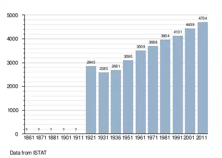
Population
Gallery
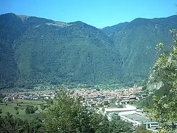
Panorama of Storo
References
- ↑ "Superficie di Comuni Province e Regioni italiane al 9 ottobre 2011". Italian National Institute of Statistics. Retrieved 16 March 2019.
- ↑ "Popolazione Residente al 1° Gennaio 2018". Italian National Institute of Statistics. Retrieved 16 March 2019.
- ↑ All demographics and other statistics: Italian statistical institute Istat, except 2011 numbers which are approximated based on 2012 information available
- 1 2 "Italian Communities". Retrieved 7 June 2012.
External links
- (in Italian) Homepage of the city

This article is issued from Wikipedia. The text is licensed under Creative Commons - Attribution - Sharealike. Additional terms may apply for the media files.