Doazit | |
|---|---|
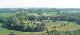 Camp du Mus | |
.svg.png.webp) Coat of arms | |
Location of Doazit | |
 Doazit  Doazit | |
| Coordinates: 43°41′29″N 0°38′42″W / 43.6914°N 0.645°W | |
| Country | France |
| Region | Nouvelle-Aquitaine |
| Department | Landes |
| Arrondissement | Dax |
| Canton | Coteau de Chalosse |
| Government | |
| • Mayor (2020–2026) | Denis Langlade[1] |
| Area 1 | 22.16 km2 (8.56 sq mi) |
| Population | 854 |
| • Density | 39/km2 (100/sq mi) |
| Time zone | UTC+01:00 (CET) |
| • Summer (DST) | UTC+02:00 (CEST) |
| INSEE/Postal code | 40089 /40700 |
| Elevation | 57–127 m (187–417 ft) (avg. 112 m or 367 ft) |
| 1 French Land Register data, which excludes lakes, ponds, glaciers > 1 km2 (0.386 sq mi or 247 acres) and river estuaries. | |
Doazit (French pronunciation: [dɔazi]; Occitan: Doasit) is a commune in the Landes department in Nouvelle-Aquitaine in southwestern France.[3]
Population
| Year | Pop. | ±% p.a. |
|---|---|---|
| 1968 | 1,032 | — |
| 1975 | 901 | −1.92% |
| 1982 | 865 | −0.58% |
| 1990 | 858 | −0.10% |
| 1999 | 884 | +0.33% |
| 2009 | 904 | +0.22% |
| 2014 | 886 | −0.40% |
| 2020 | 856 | −0.57% |
| Source: INSEE[4] | ||
See also
References
- ↑ "Répertoire national des élus: les maires" (in French). data.gouv.fr, Plateforme ouverte des données publiques françaises. 13 September 2022.
- ↑ "Populations légales 2021". The National Institute of Statistics and Economic Studies. 28 December 2023.
- ↑ INSEE commune file
- ↑ Population en historique depuis 1968, INSEE
Wikimedia Commons has media related to Doazit.
This article is issued from Wikipedia. The text is licensed under Creative Commons - Attribution - Sharealike. Additional terms may apply for the media files.