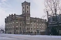
Jánoshalma | |
|---|---|
 | |
 Flag  Coat of arms | |
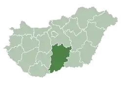
 Jánoshalma Location of Jánoshalma | |
| Coordinates: 46°17′48″N 19°19′22″E / 46.29671°N 19.32283°E | |
| Country | |
| County | Bács-Kiskun |
| District | Jánoshalma |
| Area | |
| • Total | 132.21 km2 (51.05 sq mi) |
| Population (2008) | |
| • Total | 9,433 |
| • Density | 74.48/km2 (192.9/sq mi) |
| Time zone | UTC+1 (CET) |
| • Summer (DST) | UTC+2 (CEST) |
| Postal code | 6440 |
| Area code | (+36) 77 |
| Website | www |
Jánoshalma (Croatian: Jankovac) is a town in Bács-Kiskun county in southern Hungary.
References
External links
Wikimedia Commons has media related to Jánoshalma.
- Official website in Hungarian
| Towns (2) |
| |
|---|---|---|
| Villages (3) | ||
This article is issued from Wikipedia. The text is licensed under Creative Commons - Attribution - Sharealike. Additional terms may apply for the media files.