Kuželov | |
|---|---|
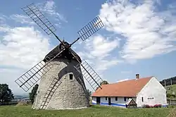 Windmill | |
 Flag  Coat of arms | |
 Kuželov Location in the Czech Republic | |
| Coordinates: 48°51′35″N 17°29′20″E / 48.85972°N 17.48889°E | |
| Country | |
| Region | South Moravian |
| District | Hodonín |
| First mentioned | 1406 |
| Area | |
| • Total | 10.15 km2 (3.92 sq mi) |
| Elevation | 294 m (965 ft) |
| Population (2023-01-01)[1] | |
| • Total | 410 |
| • Density | 40/km2 (100/sq mi) |
| Time zone | UTC+1 (CET) |
| • Summer (DST) | UTC+2 (CEST) |
| Postal code | 696 73 |
| Website | www |
Kuželov (German: Kuzelau) is a municipality and village in Hodonín District in the South Moravian Region of the Czech Republic. It has about 400 inhabitants.
Kuželov, a part of traditional ethnographic region Horňácko, lies approximately 27 kilometres (17 mi) east of Hodonín, 75 km (47 mi) south-east of Brno, and 262 km (163 mi) south-east of Prague.
Sights
Kuželov is known for a windmill, protected as a national cultural monument. It dates from 1842. It is a rare example of preserved Holland-type windmill. After the reconstruction, the mill is functional again and its interior houses an exposition about milling and life in the Horňácko region.[2]
References
- ↑ "Population of Municipalities – 1 January 2023". Czech Statistical Office. 2023-05-23.
- ↑ "Větrný mlýn v Kuželově" (in Czech). CzechTourism. Retrieved 2022-06-28.
Wikimedia Commons has media related to Kuželov.
This article is issued from Wikipedia. The text is licensed under Creative Commons - Attribution - Sharealike. Additional terms may apply for the media files.