Syrovín | |
|---|---|
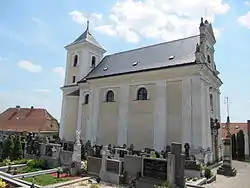 Church of the Conversion of Saint Paul | |
 Flag  Coat of arms | |
 Syrovín Location in the Czech Republic | |
| Coordinates: 49°1′33″N 17°15′50″E / 49.02583°N 17.26389°E | |
| Country | |
| Region | South Moravian |
| District | Hodonín |
| First mentioned | 1371 |
| Area | |
| • Total | 4.08 km2 (1.58 sq mi) |
| Elevation | 244 m (801 ft) |
| Population (2023-01-01)[1] | |
| • Total | 350 |
| • Density | 86/km2 (220/sq mi) |
| Time zone | UTC+1 (CET) |
| • Summer (DST) | UTC+2 (CEST) |
| Postal code | 696 84 |
| Website | www |
Syrovín is a municipality and village in Hodonín District in the South Moravian Region of the Czech Republic. It has about 400 inhabitants.
Syrovín lies approximately 22 kilometres (14 mi) north-east of Hodonín, 51 km (32 mi) south-east of Brno, and 237 km (147 mi) south-east of Prague.
References
Wikimedia Commons has media related to Syrovín.
This article is issued from Wikipedia. The text is licensed under Creative Commons - Attribution - Sharealike. Additional terms may apply for the media files.