Manjakatompo | |
|---|---|
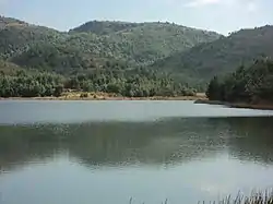 Lake of Manjakatompo | |
 Manjakatompo Location in Madagascar | |
| Coordinates: 19°20′S 47°26′E / 19.333°S 47.433°E | |
| Country | |
| Region | Vakinankaratra |
| District | Ambatolampy |
| Elevation | 1,552 m (5,092 ft) |
| Population (2001)[2] | |
| • Total | 6,000 |
| Time zone | UTC3 (EAT) |
Manjakatompo is a town and commune in Madagascar. It belongs to the district of Ambatolampy, which is a part of Vakinankaratra Region. The population of the commune was estimated to be approximately 6,000 in 2001 commune census.[2]
The town is situated near the Ankaratra massif and the third highest peak of Madagascar, Mount Tsiafajavona (2643 meters).
There is a forest station near the town covering 8320 ha.[3]
References and notes
- ↑ Estimated based on DEM data from Shuttle Radar Topography Mission
- 1 2 "ILO census data". Cornell University. 2002. Retrieved 2008-04-22.
- ↑ www.madagascar-guide.com
Capital: Antsirabe | ||
| Ambatolampy (19) | 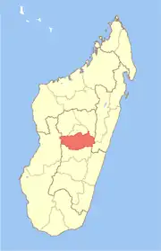 | |
| Antanifotsy (14) | ||
| Antsirabe I (1) | ||
| Antsirabe II (20) | ||
| Betafo (18) | ||
| Faratsiho (9) | ||
| Mandoto (9) | ||
7 districts; 89 communes | ||
19°20′S 47°26′E / 19.333°S 47.433°E
This article is issued from Wikipedia. The text is licensed under Creative Commons - Attribution - Sharealike. Additional terms may apply for the media files.