Maroantsetra (district) | |
|---|---|
Commune and town | |
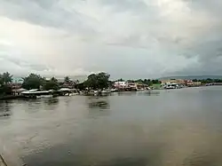 Port of Maroantsetra | |
 Maroantsetra (district) Location in Madagascar | |
| Coordinates: 15°26′0″S 49°45′0″E / 15.43333°S 49.75000°E | |
| Country | |
| Region | Analanjirofo |
| District | Maroantsetra |
| Elevation | 14 m (46 ft) |
| Time zone | UTC3 (EAT) |
| Postal code | 512 |
Maroantsetra is a district of Analanjirofo in Madagascar.[1][2] It hosts part of Masoala National Park and part of Makira Natural Park.
Communes
The district is further divided into 20 communes:
Rivers
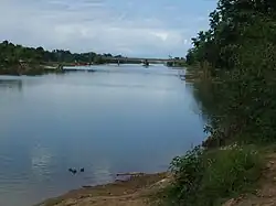
The Ivoloina River at Voloina
This district is crossed by the Rantabe river, Ivoloina River, Antainambalana River, Manambolo (Est), Amaranofotsy, Mahalevona River and the Ambanizana.[3]
References
- ↑ REPOBLIKAN’I MADAGASIKARA:Tanindrazana – Fahafahana – Fandrosoana (PDF). MINISTERE DE L’AGRICULTURE, DE L’ELEVAGE ET DE LA PECHE. October 2007. pp. 42–44. Archived from the original (PDF) on 2018-06-12. Retrieved 2018-06-09.
- ↑ "Madagascar: Administrative Division". citypopulation. Retrieved 10 June 2018.
- ↑ Monographie Region
Capital: Fenoarivo Atsinanana | ||
| Fenerive Est (509) | 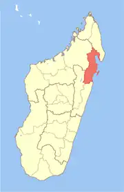 | |
| Mananara Nord (511) | ||
| Maroantsetra (512) | ||
| Sainte Marie (Nosy Boraha) (515) | ||
| Soanierana Ivongo (516) | ||
| Vavatenina (518) | ||
6 districts; 71 communes | ||
This article is issued from Wikipedia. The text is licensed under Creative Commons - Attribution - Sharealike. Additional terms may apply for the media files.