Montsûrs | |
|---|---|
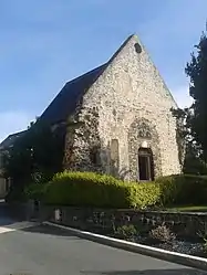 The Chapel of Saint-Martin, in Montsûrs | |
 Coat of arms | |
Location of Montsûrs | |
 Montsûrs  Montsûrs | |
| Coordinates: 48°08′05″N 0°33′09″W / 48.1347°N 0.5525°W | |
| Country | France |
| Region | Pays de la Loire |
| Department | Mayenne |
| Arrondissement | Mayenne |
| Canton | Évron |
| Area 1 | 68.14 km2 (26.31 sq mi) |
| Population | 3,193 |
| • Density | 47/km2 (120/sq mi) |
| Time zone | UTC+01:00 (CET) |
| • Summer (DST) | UTC+02:00 (CEST) |
| INSEE/Postal code | 53161 /53150 |
| Elevation | 62–151 m (203–495 ft) (avg. 89 m or 292 ft) |
| 1 French Land Register data, which excludes lakes, ponds, glaciers > 1 km2 (0.386 sq mi or 247 acres) and river estuaries. | |
Montsûrs (French pronunciation: [mɔ̃syʁ]) is a commune in the Mayenne department in north-western France. On 1 January 2017, it was merged with Saint-Céneré and formed the short-lived commune Montsûrs-Saint-Céneré.[2] Montsûrs-Saint-Céneré was merged with Deux-Évailles, Montourtier and Saint-Ouën-des-Vallons on 1 January 2019, and the new commune took the name of Montsûrs.[3] The river Jouanne flows through the commune.[4]
Population
| Year | Pop. | ±% p.a. |
|---|---|---|
| 1968 | 3,016 | — |
| 1975 | 3,131 | +0.54% |
| 1982 | 3,216 | +0.38% |
| 1990 | 3,126 | −0.35% |
| 1999 | 3,109 | −0.06% |
| 2007 | 3,241 | +0.52% |
| 2012 | 3,316 | +0.46% |
| 2017 | 3,227 | −0.54% |
| Source: INSEE[5] | ||
Points of interest
See also
References
- ↑ "Populations légales 2021". The National Institute of Statistics and Economic Studies. 28 December 2023.
- ↑ Arrêté préfectoral 29 September 2016 (in French)
- ↑ Arrêté préfectoral 12 December 2018 (in French)
- ↑ Sandre. "Fiche cours d'eau - Jouanne (M34-0300)".
- ↑ Population en historique depuis 1968, INSEE
Wikimedia Commons has media related to Montsûrs.
This article is issued from Wikipedia. The text is licensed under Creative Commons - Attribution - Sharealike. Additional terms may apply for the media files.