Pázmánd | |
|---|---|
 Flag  Coat of arms | |
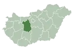
 Pázmánd Location of Pázmánd | |
| Coordinates: 47°17′15″N 18°39′15″E / 47.28745°N 18.65425°E | |
| Country | |
| County | Fejér |
| Area | |
| • Total | 27.14 km2 (10.48 sq mi) |
| Population (2004) | |
| • Total | 2,015 |
| • Density | 74.24/km2 (192.3/sq mi) |
| Time zone | UTC+1 (CET) |
| • Summer (DST) | UTC+2 (CEST) |
| Postal code | 2476 |
| Area code | 22 |
| Motorways | M7 |
| Distance from Budapest | 44.6 km (27.7 mi) Northeast |
| Website | www |
Pázmánd is a village in Fejér county, Hungary. As of 2004, it had 2,015 residents.
Gallery
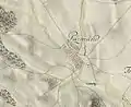 The map of Pázmánd from the First Military Mapping Survey of Austria Empire.
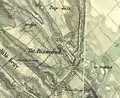 The map of Pázmánd from the Second Military Mapping Survey of Austria Empire.
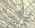 The map of Pázmánd from the 3rd Military Mapping Survey of Austria Empire.
External links
 Media related to Pázmánd at Wikimedia Commons
- Street map (in Hungarian)
| Cities with county rights |
|   |
|---|---|---|
| Towns | ||
| Large villages | ||
| Villages |
| |
| Other topics |
| |
This article is issued from Wikipedia. The text is licensed under Creative Commons - Attribution - Sharealike. Additional terms may apply for the media files.