Sárkeresztes | |
|---|---|
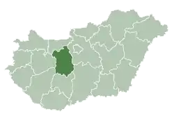
 Sárkeresztes Location of Sárkeresztes | |
| Coordinates: 47°15′06″N 18°21′11″E / 47.25164°N 18.35307°E | |
| Country | |
| County | Fejér |
| Area | |
| • Total | 23.27 km2 (8.98 sq mi) |
| Population (2015) | |
| • Total | 1,525 |
| • Density | 64.71/km2 (167.6/sq mi) |
| Time zone | UTC+1 (CET) |
| • Summer (DST) | UTC+2 (CEST) |
| Postal code | 8051 |
| Area code | 22 |
| Website | www |
External links
- Street map (in Hungarian)
| Cities with county rights |
|   |
|---|---|---|
| Towns | ||
| Large villages | ||
| Villages |
| |
| Other topics |
| |
This article is issued from Wikipedia. The text is licensed under Creative Commons - Attribution - Sharealike. Additional terms may apply for the media files.