Würflach | |
|---|---|
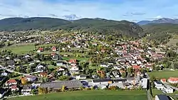 East view of Würflach | |
 Coat of arms | |
 Würflach Location within Austria | |
| Coordinates: 47°47′N 16°3′E / 47.783°N 16.050°E | |
| Country | Austria |
| State | Lower Austria |
| District | Neunkirchen |
| Government | |
| • Mayor | Franz Woltron (ÖVP) |
| Area | |
| • Total | 12.33 km2 (4.76 sq mi) |
| Elevation | 430 m (1,410 ft) |
| Population (2018-01-01)[2] | |
| • Total | 1,592 |
| • Density | 130/km2 (330/sq mi) |
| Time zone | UTC+1 (CET) |
| • Summer (DST) | UTC+2 (CEST) |
| Postal code | 2732 |
| Area code | +43 2630 |
| Website | http://www.wuerflach.at |
Würflach is a town in the district of Neunkirchen in the Austrian state of Lower Austria.
Population
| Year | Pop. | ±% |
|---|---|---|
| 1869 | 710 | — |
| 1880 | 765 | +7.7% |
| 1890 | 819 | +7.1% |
| 1900 | 833 | +1.7% |
| 1910 | 894 | +7.3% |
| 1923 | 918 | +2.7% |
| 1934 | 918 | +0.0% |
| 1939 | 937 | +2.1% |
| 1951 | 1,000 | +6.7% |
| 1961 | 1,037 | +3.7% |
| 1971 | 1,146 | +10.5% |
| 1981 | 1,251 | +9.2% |
| 1991 | 1,313 | +5.0% |
| 2001 | 1,483 | +12.9% |
| 2011 | 1,581 | +6.6% |
References
- ↑ "Dauersiedlungsraum der Gemeinden Politischen Bezirke und Bundesländer - Gebietsstand 1.1.2018". Statistics Austria. Retrieved 10 March 2019.
- ↑ "Einwohnerzahl 1.1.2018 nach Gemeinden mit Status, Gebietsstand 1.1.2018". Statistics Austria. Retrieved 9 March 2019.
This article is issued from Wikipedia. The text is licensed under Creative Commons - Attribution - Sharealike. Additional terms may apply for the media files.