Fraisse-sur-Agout | |
|---|---|
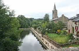 The Agout, the village and the bell tower of Saint-Jean-Baptiste | |
 Coat of arms | |
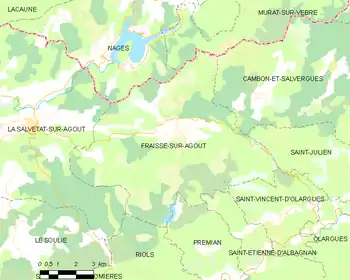
Location of Fraisse-sur-Agout | |
 Fraisse-sur-Agout  Fraisse-sur-Agout | |
| Coordinates: 43°36′25″N 2°47′54″E / 43.6069°N 2.7983°E | |
| Country | France |
| Region | Occitania |
| Department | Hérault |
| Arrondissement | Béziers |
| Canton | Saint-Pons-de-Thomières |
| Intercommunality | Monts de Lacaune et Montagne du Haut Languedoc |
| Government | |
| • Mayor (2020–2026) | Jim Ronez[1] |
| Area 1 | 58.46 km2 (22.57 sq mi) |
| Population | 339 |
| • Density | 5.8/km2 (15/sq mi) |
| Time zone | UTC+01:00 (CET) |
| • Summer (DST) | UTC+02:00 (CEST) |
| INSEE/Postal code | 34107 /34330 |
| Elevation | 435–1,111 m (1,427–3,645 ft) (avg. 700 m or 2,300 ft) |
| 1 French Land Register data, which excludes lakes, ponds, glaciers > 1 km2 (0.386 sq mi or 247 acres) and river estuaries. | |
Fraisse-sur-Agout is a commune in the Hérault department in southern France.
Map
Population
| Year | Pop. | ±% |
|---|---|---|
| 1962 | 232 | — |
| 1968 | 294 | +26.7% |
| 1975 | 270 | −8.2% |
| 1982 | 266 | −1.5% |
| 1990 | 249 | −6.4% |
| 1999 | 322 | +29.3% |
| 2008 | 352 | +9.3% |
See also
References
- ↑ "Répertoire national des élus: les maires". data.gouv.fr, Plateforme ouverte des données publiques françaises (in French). 9 August 2021.
- ↑ "Populations légales 2021". The National Institute of Statistics and Economic Studies. 28 December 2023.
Wikimedia Commons has media related to Fraisse-sur-Agout.
This article is issued from Wikipedia. The text is licensed under Creative Commons - Attribution - Sharealike. Additional terms may apply for the media files.