Laurac | |
|---|---|
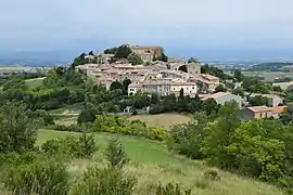 The church and surroundings in Laurac | |
.svg.png.webp) Coat of arms | |
Location of Laurac | |
 Laurac  Laurac | |
| Coordinates: 43°14′00″N 1°59′00″E / 43.2333°N 1.9833°E | |
| Country | France |
| Region | Occitania |
| Department | Aude |
| Arrondissement | Carcassonne |
| Canton | La Piège au Razès |
| Government | |
| • Mayor (2020–2026) | Yolande Steenkeste[1] |
| Area 1 | 1.158 km2 (0.447 sq mi) |
| Population | 181 |
| • Density | 160/km2 (400/sq mi) |
| Time zone | UTC+01:00 (CET) |
| • Summer (DST) | UTC+02:00 (CEST) |
| INSEE/Postal code | 11196 /11270 |
| Elevation | 196–413 m (643–1,355 ft) (avg. 410 m or 1,350 ft) |
| 1 French Land Register data, which excludes lakes, ponds, glaciers > 1 km2 (0.386 sq mi or 247 acres) and river estuaries. | |
Laurac (French pronunciation: [loʁak] ⓘ; Occitan: Laurac) is a commune in the Aude department in southern France.
Population
| Year | Pop. | ±% p.a. |
|---|---|---|
| 1968 | 153 | — |
| 1975 | 123 | −3.07% |
| 1982 | 118 | −0.59% |
| 1990 | 140 | +2.16% |
| 1999 | 124 | −1.34% |
| 2009 | 176 | +3.56% |
| 2014 | 172 | −0.46% |
| 2020 | 181 | +0.85% |
| Source: INSEE[3] | ||
See also
References
- ↑ "Répertoire national des élus: les maires". data.gouv.fr, Plateforme ouverte des données publiques françaises (in French). 9 August 2021.
- ↑ "Populations légales 2021". The National Institute of Statistics and Economic Studies. 28 December 2023.
- ↑ Population en historique depuis 1968, INSEE
Wikimedia Commons has media related to Laurac.
This article is issued from Wikipedia. The text is licensed under Creative Commons - Attribution - Sharealike. Additional terms may apply for the media files.