Montredon-des-Corbières | |
|---|---|
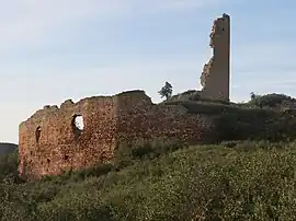 Ruins of the chateau of Saint Pierre des Clars | |
.svg.png.webp) Coat of arms | |
Location of Montredon-des-Corbières | |
 Montredon-des-Corbières  Montredon-des-Corbières | |
| Coordinates: 43°11′32″N 2°55′36″E / 43.1922°N 2.9267°E | |
| Country | France |
| Region | Occitania |
| Department | Aude |
| Arrondissement | Narbonne |
| Canton | Narbonne-1 |
| Intercommunality | Grand Narbonne |
| Government | |
| • Mayor (2020–2026) | Jean-Marc Jansana[1] |
| Area 1 | 17.15 km2 (6.62 sq mi) |
| Population | 1,480 |
| • Density | 86/km2 (220/sq mi) |
| Time zone | UTC+01:00 (CET) |
| • Summer (DST) | UTC+02:00 (CEST) |
| INSEE/Postal code | 11255 /11100 |
| Elevation | 28–176 m (92–577 ft) (avg. 35 m or 115 ft) |
| 1 French Land Register data, which excludes lakes, ponds, glaciers > 1 km2 (0.386 sq mi or 247 acres) and river estuaries. | |
Montredon-des-Corbières is a commune in the Aude department in southern France.
Population
| Year | Pop. | ±% |
|---|---|---|
| 1962 | 640 | — |
| 1968 | 645 | +0.8% |
| 1975 | 717 | +11.2% |
| 1982 | 729 | +1.7% |
| 1990 | 850 | +16.6% |
| 1999 | 904 | +6.4% |
| 2008 | 1,104 | +22.1% |
See also
References
- ↑ "Répertoire national des élus: les maires". data.gouv.fr, Plateforme ouverte des données publiques françaises (in French). 9 August 2021.
- ↑ "Populations légales 2021". The National Institute of Statistics and Economic Studies. 28 December 2023.
Wikimedia Commons has media related to Montredon-des-Corbières.
This article is issued from Wikipedia. The text is licensed under Creative Commons - Attribution - Sharealike. Additional terms may apply for the media files.