 | ||||
|---|---|---|---|---|
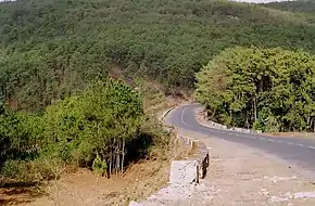 NH 6 in Meghalaya | ||||
| Route information | ||||
| Part of | ||||
| Length | 667 km (414 mi) | |||
| Major junctions | ||||
| North end | Jorabat | |||
| South end | Zokhawthar India/Myanmar border | |||
| Location | ||||
| Country | India | |||
| States | Meghalaya, Assam, Mizoram | |||
| Highway system | ||||
| ||||
National Highway 6, commonly referred to as NH 6, is a primary national highway in India.[1] The highway passes through the Indian states of Meghalaya, Assam, and Mizoram.[2] Before renumbering of national highways NH-6 was variously numbered as old national highways 40, 44, 154 & 54.[3]
Route
NH6 links Jorabat, Shillong, Jowai, Badarpur, Panchgram, Kolasib, Kanpui, Aizawl, Seling, Lumtui, Khawthlir, Tuisen, Neihdawn, Champhai and terminates near Zokhawthar at India/Myanmar border.[2][4] In sept 2008, a 120 meter long tunnel was built at Sonapur in Meghalaya inside the Narpuh Sanctuary northwest of Silchar, it connects Meghalaya with Assam's Barak Valley in Meghalaya's southeast.[5]
Junctions
Asian Highways
Jorabat to Shillong stretch of National Highway 6 is part of Asian Highway 1 and Asian Highway 2.[6]
See also
References
- ↑ "Rationalization of Numbering Systems of National Highways" (PDF). Govt of India. 28 April 2010. Retrieved 21 August 2011.
- 1 2 3 "State-wise length of National Highways (NH) in India". Ministry of Road Transport and Highways. Retrieved 25 April 2019.
- ↑ "New Numbering of National Highways notification - Government of India" (PDF). The Gazette of India. Retrieved 25 April 2019.
- ↑ "Route substituition for national highways 302 and 6" (PDF). The Gazette of India. Retrieved 25 April 2019.
- ↑ CITYBorder Roads Organisation blazes a trail in most testing conditions, Times of India, 18 nov 2022.
- ↑ "Asian Highway Database - Country wise". UNESCAP. Retrieved 25 April 2019.
External links


Secondary routes of Indian National Highway 6 | ||
|---|---|---|
| States | | |
| Secondary routes | ||
| Across the whole continent | 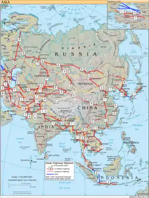 | |
|---|---|---|
| Southeast Asia | ||
| East Asia, Northeast Asia and Southeast Asia | ||
| South Asia | ||
| North Asia, Central Asia and Southwest Asia | ||