Teillet-Argenty | |
|---|---|
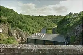 The Rochebut Dam, on the Cher river, between Mazirat and Teillet-Argenty | |
Location of Teillet-Argenty | |
 Teillet-Argenty  Teillet-Argenty | |
| Coordinates: 46°15′37″N 2°30′46″E / 46.2603°N 2.5128°E | |
| Country | France |
| Region | Auvergne-Rhône-Alpes |
| Department | Allier |
| Arrondissement | Montluçon |
| Canton | Montluçon-4 |
| Intercommunality | CA Montluçon Communauté |
| Government | |
| • Mayor (2020–2026) | Joële Gérinier[1] |
| Area 1 | 21.99 km2 (8.49 sq mi) |
| Population | 554 |
| • Density | 25/km2 (65/sq mi) |
| Time zone | UTC+01:00 (CET) |
| • Summer (DST) | UTC+02:00 (CEST) |
| INSEE/Postal code | 03279 /03410 |
| Elevation | 238–432 m (781–1,417 ft) (avg. 379 m or 1,243 ft) |
| 1 French Land Register data, which excludes lakes, ponds, glaciers > 1 km2 (0.386 sq mi or 247 acres) and river estuaries. | |
Teillet-Argenty (French pronunciation: [tɛjɛ aʁʒɑ̃ti]; Occitan: Telhet e Argentier) is a commune in the Allier department in Auvergne-Rhône-Alpes in central France.
Population
| Year | Pop. | ±% |
|---|---|---|
| 1962 | 520 | — |
| 1968 | 528 | +1.5% |
| 1975 | 458 | −13.3% |
| 1982 | 448 | −2.2% |
| 1990 | 474 | +5.8% |
| 1999 | 472 | −0.4% |
| 2008 | 517 | +9.5% |
| 2013 | 575 | +11.2% |
| Source: INSEE (1968–2013) | ||
See also
References
- ↑ "Répertoire national des élus: les maires" (in French). data.gouv.fr, Plateforme ouverte des données publiques françaises. 13 September 2022.
- ↑ "Populations légales 2021". The National Institute of Statistics and Economic Studies. 28 December 2023.
Wikimedia Commons has media related to Teillet-Argenty.
This article is issued from Wikipedia. The text is licensed under Creative Commons - Attribution - Sharealike. Additional terms may apply for the media files.