Availles-Limouzine | |
|---|---|
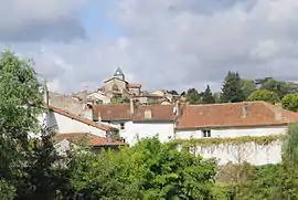 The church and surrounding buildings in Availles-Limouzine | |
.svg.png.webp) Coat of arms | |
Location of Availles-Limouzine | |
 Availles-Limouzine  Availles-Limouzine | |
| Coordinates: 46°07′19″N 0°39′23″E / 46.1219°N 0.6564°E | |
| Country | France |
| Region | Nouvelle-Aquitaine |
| Department | Vienne |
| Arrondissement | Montmorillon |
| Canton | Civray |
| Intercommunality | CC Vienne Gartempe |
| Government | |
| • Mayor (2020–2026) | Liliane Chabauty[1] |
| Area 1 | 57.90 km2 (22.36 sq mi) |
| Population | 1,262 |
| • Density | 22/km2 (56/sq mi) |
| Time zone | UTC+01:00 (CET) |
| • Summer (DST) | UTC+02:00 (CEST) |
| INSEE/Postal code | 86015 /86460 |
| Elevation | 120–224 m (394–735 ft) (avg. 60 m or 200 ft) |
| 1 French Land Register data, which excludes lakes, ponds, glaciers > 1 km2 (0.386 sq mi or 247 acres) and river estuaries. | |
Availles-Limouzine (French pronunciation: [avaj limuzin]; Occitan: Avalha Lemosina) is a commune in the west-central department of Vienne, in Nouvelle-Aquitaine.
The river Clouère flows north-westward through the western part of the commune, then forms its northwestern border. The river Vienne forms part of the commune's south-eastern border, then flows northward through the commune; the town lies on its left bank.
References
- ↑ "Répertoire national des élus: les maires" (in French). data.gouv.fr, Plateforme ouverte des données publiques françaises. 13 September 2022.
- ↑ "Populations légales 2021". The National Institute of Statistics and Economic Studies. 28 December 2023.
Wikimedia Commons has media related to Availles-Limouzine.
This article is issued from Wikipedia. The text is licensed under Creative Commons - Attribution - Sharealike. Additional terms may apply for the media files.