Ranton | |
|---|---|
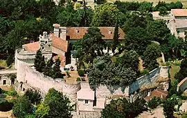 The Chateau of Ranton | |
 Coat of arms | |
Location of Ranton | |
 Ranton  Ranton | |
| Coordinates: 47°00′03″N 0°01′39″W / 47.0008°N 0.0275°W | |
| Country | France |
| Region | Nouvelle-Aquitaine |
| Department | Vienne |
| Arrondissement | Châtellerault |
| Canton | Loudun |
| Intercommunality | Pays Loudunais |
| Government | |
| • Mayor (2020–2026) | Pascal Brault[1] |
| Area 1 | 6.07 km2 (2.34 sq mi) |
| Population | 204 |
| • Density | 34/km2 (87/sq mi) |
| Time zone | UTC+01:00 (CET) |
| • Summer (DST) | UTC+02:00 (CEST) |
| INSEE/Postal code | 86205 /86200 |
| Elevation | 45–123 m (148–404 ft) (avg. 122 m or 400 ft) |
| 1 French Land Register data, which excludes lakes, ponds, glaciers > 1 km2 (0.386 sq mi or 247 acres) and river estuaries. | |
Ranton (French pronunciation: [ʁɑ̃tɔ̃]) is a commune in the Vienne department in the Nouvelle-Aquitaine region in western France.
Demographics
| Year | Pop. | ±% p.a. |
|---|---|---|
| 1968 | 227 | — |
| 1975 | 219 | −0.51% |
| 1982 | 174 | −3.23% |
| 1990 | 195 | +1.43% |
| 1999 | 202 | +0.39% |
| 2007 | 192 | −0.63% |
| 2012 | 183 | −0.96% |
| 2017 | 193 | +1.07% |
| Source: INSEE[3] | ||
See also
References
- ↑ "Répertoire national des élus: les maires". data.gouv.fr, Plateforme ouverte des données publiques françaises (in French). 9 August 2021.
- ↑ "Populations légales 2021". The National Institute of Statistics and Economic Studies. 28 December 2023.
- ↑ Population en historique depuis 1968, INSEE
Wikimedia Commons has media related to Ranton.
This article is issued from Wikipedia. The text is licensed under Creative Commons - Attribution - Sharealike. Additional terms may apply for the media files.