Chirat-l'Église | |
|---|---|
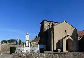 The church in Chirat-l'Eglise | |
Location of Chirat-l'Église | |
 Chirat-l'Église  Chirat-l'Église | |
| Coordinates: 46°14′38″N 3°02′07″E / 46.2439°N 3.0353°E | |
| Country | France |
| Region | Auvergne-Rhône-Alpes |
| Department | Allier |
| Arrondissement | Vichy |
| Canton | Gannat |
| Intercommunality | Saint-Pourçain Sioule Limagne |
| Government | |
| • Mayor (2020–2026) | Josiane Henry[1] |
| Area 1 | 18.48 km2 (7.14 sq mi) |
| Population | 128 |
| • Density | 6.9/km2 (18/sq mi) |
| Time zone | UTC+01:00 (CET) |
| • Summer (DST) | UTC+02:00 (CEST) |
| INSEE/Postal code | 03077 /03330 |
| Elevation | 311–494 m (1,020–1,621 ft) (avg. 450 m or 1,480 ft) |
| 1 French Land Register data, which excludes lakes, ponds, glaciers > 1 km2 (0.386 sq mi or 247 acres) and river estuaries. | |
Chirat-l'Église (French pronunciation: [ʃiʁa leɡliz]; Occitan: Chirac de la Glèisa) is a commune in the Allier department in Auvergne in central France.
Geography
The river Bouble forms all of the commune's northwestern border and most of its northeastern border.
Population
| Year | Pop. | ±% |
|---|---|---|
| 1962 | 175 | — |
| 1968 | 221 | +26.3% |
| 1975 | 162 | −26.7% |
| 1982 | 166 | +2.5% |
| 1990 | 129 | −22.3% |
| 1999 | 119 | −7.8% |
| 2008 | 136 | +14.3% |
| 2012 | 132 | −2.9% |
See also
References
- ↑ "Répertoire national des élus: les maires" (in French). data.gouv.fr, Plateforme ouverte des données publiques françaises. 13 September 2022.
- ↑ "Populations légales 2021". The National Institute of Statistics and Economic Studies. 28 December 2023.
Wikimedia Commons has media related to Chirat-l'Église.
This article is issued from Wikipedia. The text is licensed under Creative Commons - Attribution - Sharealike. Additional terms may apply for the media files.