Dargoire | |
|---|---|
 | |
.svg.png.webp) Coat of arms | |
Location of Dargoire | |
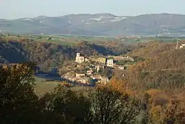
 Dargoire  Dargoire | |
| Coordinates: 45°33′40″N 4°40′06″E / 45.5611°N 4.6683°E | |
| Country | France |
| Region | Auvergne-Rhône-Alpes |
| Department | Loire |
| Arrondissement | Saint-Étienne |
| Canton | Rive-de-Gier |
| Intercommunality | Saint-Étienne Métropole |
| Government | |
| • Mayor (2020–2026) | Marc Jandot[1] |
| Area 1 | 1.92 km2 (0.74 sq mi) |
| Population | 526 |
| • Density | 270/km2 (710/sq mi) |
| Time zone | UTC+01:00 (CET) |
| • Summer (DST) | UTC+02:00 (CEST) |
| INSEE/Postal code | 42083 /42800 |
| Elevation | 189–335 m (620–1,099 ft) (avg. 245 m or 804 ft) |
| 1 French Land Register data, which excludes lakes, ponds, glaciers > 1 km2 (0.386 sq mi or 247 acres) and river estuaries. | |
Dargoire (French pronunciation: [daʁɡwaʁ]) is a commune in the Loire department in central France.
Population
| Year | Pop. | ±% p.a. |
|---|---|---|
| 1968 | 111 | — |
| 1975 | 159 | +5.27% |
| 1982 | 289 | +8.91% |
| 1990 | 428 | +5.03% |
| 1999 | 409 | −0.50% |
| 2009 | 436 | +0.64% |
| 2014 | 490 | +2.36% |
| 2020 | 529 | +1.28% |
| Source: INSEE[3] | ||
See also
References
- ↑ "Répertoire national des élus: les maires". data.gouv.fr, Plateforme ouverte des données publiques françaises (in French). 2 December 2020.
- ↑ "Populations légales 2021". The National Institute of Statistics and Economic Studies. 28 December 2023.
- ↑ Population en historique depuis 1968, INSEE
Wikimedia Commons has media related to Dargoire.
This article is issued from Wikipedia. The text is licensed under Creative Commons - Attribution - Sharealike. Additional terms may apply for the media files.