Rouhe | |
|---|---|
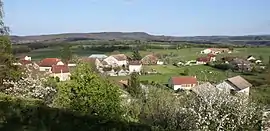 A general view of Rouhe | |
Location of Rouhe | |
 Rouhe  Rouhe | |
| Coordinates: 47°05′01″N 5°57′53″E / 47.0836°N 5.9647°E | |
| Country | France |
| Region | Bourgogne-Franche-Comté |
| Department | Doubs |
| Arrondissement | Besançon |
| Canton | Saint-Vit |
| Intercommunality | Loue-Lison |
| Government | |
| • Mayor (2020–2026) | Marie-Christine Legain[1] |
| Area 1 | 4.19 km2 (1.62 sq mi) |
| Population | 77 |
| • Density | 18/km2 (48/sq mi) |
| Time zone | UTC+01:00 (CET) |
| • Summer (DST) | UTC+02:00 (CEST) |
| INSEE/Postal code | 25507 /25440 |
| Elevation | 285–472 m (935–1,549 ft) |
| 1 French Land Register data, which excludes lakes, ponds, glaciers > 1 km2 (0.386 sq mi or 247 acres) and river estuaries. | |
Rouhe is a commune in the Doubs department in the Bourgogne-Franche-Comté region in eastern France.
Geography
Rouhe lies 25 km (16 mi) south of Besançon.
Population
| Year | Pop. | ±% |
|---|---|---|
| 1962 | 61 | — |
| 1968 | 62 | +1.6% |
| 1975 | 61 | −1.6% |
| 1982 | 58 | −4.9% |
| 1990 | 52 | −10.3% |
| 1999 | 73 | +40.4% |
| 2008 | 76 | +4.1% |
| 2012 | 87 | +14.5% |
See also
References
- ↑ "Répertoire national des élus: les maires". data.gouv.fr, Plateforme ouverte des données publiques françaises (in French). 2 December 2020.
- ↑ "Populations légales 2021". The National Institute of Statistics and Economic Studies. 28 December 2023.
External links
Wikimedia Commons has media related to Rouhe.
- Rouhe on the regional Web site (in French)
This article is issued from Wikipedia. The text is licensed under Creative Commons - Attribution - Sharealike. Additional terms may apply for the media files.