Larroque-Engalin | |
|---|---|
 The heptagonal tower in Larroque-Engalin | |
.svg.png.webp) Coat of arms | |
Location of Larroque-Engalin | |
 Larroque-Engalin  Larroque-Engalin | |
| Coordinates: 43°59′27″N 0°32′32″E / 43.9908°N 0.5422°E | |
| Country | France |
| Region | Occitania |
| Department | Gers |
| Arrondissement | Condom |
| Canton | Lectoure-Lomagne |
| Intercommunality | Lomagne Gersoise |
| Government | |
| • Mayor (2020–2026) | René Carpentier[1] |
| Area 1 | 6.16 km2 (2.38 sq mi) |
| Population | 44 |
| • Density | 7.1/km2 (18/sq mi) |
| Time zone | UTC+01:00 (CET) |
| • Summer (DST) | UTC+02:00 (CEST) |
| INSEE/Postal code | 32195 /32480 |
| Elevation | 72–203 m (236–666 ft) (avg. 156 m or 512 ft) |
| 1 French Land Register data, which excludes lakes, ponds, glaciers > 1 km2 (0.386 sq mi or 247 acres) and river estuaries. | |
Larroque-Engalin (French pronunciation: [laʁɔk ɑ̃ɡalɛ̃]; Occitan: La Ròca Engalin) is a commune in the Gers department in southwestern France.
Geography
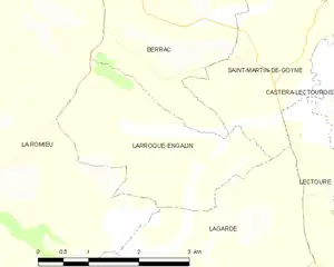
Larroque-Engalin and its surrounding communes
Population
| Year | Pop. | ±% |
|---|---|---|
| 1962 | 88 | — |
| 1968 | 86 | −2.3% |
| 1975 | 66 | −23.3% |
| 1982 | 55 | −16.7% |
| 1990 | 53 | −3.6% |
| 1999 | 59 | +11.3% |
| 2008 | 55 | −6.8% |
See also
References
- ↑ "Répertoire national des élus: les maires" (in French). data.gouv.fr, Plateforme ouverte des données publiques françaises. 13 September 2022.
- ↑ "Populations légales 2021". The National Institute of Statistics and Economic Studies. 28 December 2023.
Wikimedia Commons has media related to Larroque-Engalin.
This article is issued from Wikipedia. The text is licensed under Creative Commons - Attribution - Sharealike. Additional terms may apply for the media files.