Saint-Martin | |
|---|---|
.JPG.webp) The church in Saint-Martin | |
Location of Saint-Martin | |
 Saint-Martin  Saint-Martin | |
| Coordinates: 43°30′25″N 0°22′34″E / 43.5069°N 0.3761°E | |
| Country | France |
| Region | Occitania |
| Department | Gers |
| Arrondissement | Mirande |
| Canton | Mirande-Astarac |
| Government | |
| • Mayor (2020–2026) | Daniel Pomies[1] |
| Area 1 | 9.07 km2 (3.50 sq mi) |
| Population | 450 |
| • Density | 50/km2 (130/sq mi) |
| Time zone | UTC+01:00 (CET) |
| • Summer (DST) | UTC+02:00 (CEST) |
| INSEE/Postal code | 32389 /32300 |
| Elevation | 159–263 m (522–863 ft) |
| 1 French Land Register data, which excludes lakes, ponds, glaciers > 1 km2 (0.386 sq mi or 247 acres) and river estuaries. | |
Saint-Martin (French pronunciation: [sɛ̃ maʁtɛ̃] ⓘ; Gascon: Sent Martin) is a commune in the Gers department in southwestern France.
Geography
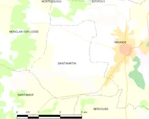
Saint-Martin and its surrounding communes
Population
| Year | Pop. | ±% |
|---|---|---|
| 1962 | 187 | — |
| 1968 | 226 | +20.9% |
| 1975 | 219 | −3.1% |
| 1982 | 338 | +54.3% |
| 1990 | 363 | +7.4% |
| 1999 | 420 | +15.7% |
| 2008 | 441 | +5.0% |
See also
References
- ↑ "Répertoire national des élus: les maires". data.gouv.fr, Plateforme ouverte des données publiques françaises (in French). 9 August 2021.
- ↑ "Populations légales 2021". The National Institute of Statistics and Economic Studies. 28 December 2023.
Wikimedia Commons has media related to Saint-Martin (Gers).
This article is issued from Wikipedia. The text is licensed under Creative Commons - Attribution - Sharealike. Additional terms may apply for the media files.