Mauvezin | |
|---|---|
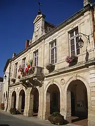 Town hall | |
.svg.png.webp) Coat of arms | |
Location of Mauvezin | |
 Mauvezin  Mauvezin | |
| Coordinates: 43°43′53″N 0°52′44″E / 43.7314°N 0.8789°E | |
| Country | France |
| Region | Occitania |
| Department | Gers |
| Arrondissement | Condom |
| Canton | Gimone-Arrats |
| Government | |
| • Mayor (2020–2026) | Alain Baqué[1] |
| Area 1 | 32.18 km2 (12.42 sq mi) |
| Population | 2,239 |
| • Density | 70/km2 (180/sq mi) |
| Time zone | UTC+01:00 (CET) |
| • Summer (DST) | UTC+02:00 (CEST) |
| INSEE/Postal code | 32249 /32120 |
| Elevation | 115–202 m (377–663 ft) (avg. 158 m or 518 ft) |
| 1 French Land Register data, which excludes lakes, ponds, glaciers > 1 km2 (0.386 sq mi or 247 acres) and river estuaries. | |
Mauvezin (French pronunciation: [mov(ə)zɛ̃]; Occitan: Mauvesin) is a commune in the Gers department, in Occitanie region in southwestern France.
Geography
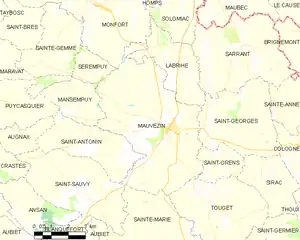
Mauvezin and its surrounding communes
Population
| Year | Pop. | ±% p.a. |
|---|---|---|
| 1968 | 1,857 | — |
| 1975 | 1,756 | −0.80% |
| 1982 | 1,705 | −0.42% |
| 1990 | 1,671 | −0.25% |
| 1999 | 1,642 | −0.19% |
| 2007 | 1,804 | +1.18% |
| 2012 | 2,025 | +2.34% |
| 2017 | 2,179 | +1.48% |
| Source: INSEE[3] | ||
See also
References
- ↑ "Répertoire national des élus: les maires" (in French). data.gouv.fr, Plateforme ouverte des données publiques françaises. 13 September 2022.
- ↑ "Populations légales 2021". The National Institute of Statistics and Economic Studies. 28 December 2023.
- ↑ Population en historique depuis 1968, INSEE
Wikimedia Commons has media related to Mauvezin (Gers).
This article is issued from Wikipedia. The text is licensed under Creative Commons - Attribution - Sharealike. Additional terms may apply for the media files.