Maignaut-Tauzia | |
|---|---|
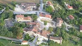 A general view of Maignaut | |
Location of Maignaut-Tauzia | |
 Maignaut-Tauzia  Maignaut-Tauzia | |
| Coordinates: 43°53′26″N 0°24′26″E / 43.8906°N 0.4072°E | |
| Country | France |
| Region | Occitania |
| Department | Gers |
| Arrondissement | Condom |
| Canton | Baïse-Armagnac |
| Government | |
| • Mayor (2020–2026) | Sandrine Redolfi de Zan[1] |
| Area 1 | 11.14 km2 (4.30 sq mi) |
| Population | 223 |
| • Density | 20/km2 (52/sq mi) |
| Time zone | UTC+01:00 (CET) |
| • Summer (DST) | UTC+02:00 (CEST) |
| INSEE/Postal code | 32224 /32310 |
| Elevation | 75–193 m (246–633 ft) (avg. 150 m or 490 ft) |
| 1 French Land Register data, which excludes lakes, ponds, glaciers > 1 km2 (0.386 sq mi or 247 acres) and river estuaries. | |
Maignaut-Tauzia (French pronunciation: [mɛɲo tozja]; Gascon: Manhaut e Tausiar) is a commune in the Gers department in southwestern France.
Geography
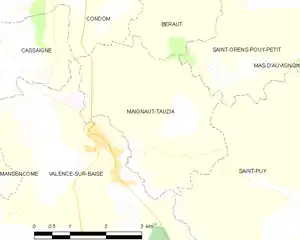
Maignaut-Tauzia and its surrounding communes
Population
| Year | Pop. | ±% p.a. |
|---|---|---|
| 1968 | 169 | — |
| 1975 | 142 | −2.46% |
| 1982 | 142 | +0.00% |
| 1990 | 195 | +4.04% |
| 1999 | 181 | −0.82% |
| 2009 | 219 | +1.92% |
| 2014 | 253 | +2.93% |
| 2020 | 228 | −1.72% |
| Source: INSEE[3] | ||
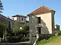 Dovecote and town gate
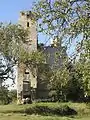 Château du Tauzia
See also
References
- ↑ "Répertoire national des élus: les maires" (in French). data.gouv.fr, Plateforme ouverte des données publiques françaises. 13 September 2022.
- ↑ "Populations légales 2021". The National Institute of Statistics and Economic Studies. 28 December 2023.
- ↑ Population en historique depuis 1968, INSEE
External links
Wikimedia Commons has media related to Maignaut-Tauzia.
This article is issued from Wikipedia. The text is licensed under Creative Commons - Attribution - Sharealike. Additional terms may apply for the media files.