Saint-Ouen-le-Pin | |
|---|---|
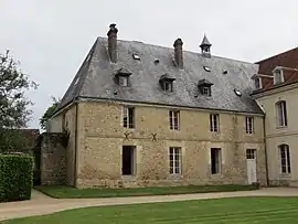 The abbey of Val-Richer | |
Location of Saint-Ouen-le-Pin | |
 Saint-Ouen-le-Pin  Saint-Ouen-le-Pin | |
| Coordinates: 49°08′56″N 0°06′27″E / 49.1489°N 0.1075°E | |
| Country | France |
| Region | Normandy |
| Department | Calvados |
| Arrondissement | Lisieux |
| Canton | Mézidon Vallée d'Auge |
| Intercommunality | CA Lisieux Normandie |
| Government | |
| • Mayor (2020–2026) | Paul Cléradin[1] |
| Area 1 | 5.59 km2 (2.16 sq mi) |
| Population | 256 |
| • Density | 46/km2 (120/sq mi) |
| Time zone | UTC+01:00 (CET) |
| • Summer (DST) | UTC+02:00 (CEST) |
| INSEE/Postal code | 14639 /14340 |
| Elevation | 94–166 m (308–545 ft) (avg. 36 m or 118 ft) |
| 1 French Land Register data, which excludes lakes, ponds, glaciers > 1 km2 (0.386 sq mi or 247 acres) and river estuaries. | |
Saint-Ouen-le-Pin (French pronunciation: [sɛ̃.t‿wɛ̃ lə pɛ̃] ⓘ) is a commune in the Calvados department in the Normandy region in northwestern France.
Population
| Year | Pop. | ±% |
|---|---|---|
| 1962 | 196 | — |
| 1968 | 201 | +2.6% |
| 1975 | 211 | +5.0% |
| 1982 | 226 | +7.1% |
| 1990 | 276 | +22.1% |
| 1999 | 267 | −3.3% |
| 2008 | 297 | +11.2% |
See also
References
- ↑ "Répertoire national des élus: les maires". data.gouv.fr, Plateforme ouverte des données publiques françaises (in French). 9 August 2021.
- ↑ "Populations légales 2021". The National Institute of Statistics and Economic Studies. 28 December 2023.
Wikimedia Commons has media related to Saint-Ouen-le-Pin.
This article is issued from Wikipedia. The text is licensed under Creative Commons - Attribution - Sharealike. Additional terms may apply for the media files.