Blassac | |
|---|---|
Commune | |
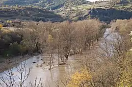 In the distance: the church of Saint-Roch, perched on its volcanic promontory above the flooded Allier in November 2008 | |
Location of Blassac | |
 Blassac  Blassac | |
| Coordinates: 45°10′16″N 3°24′02″E / 45.1711°N 3.4006°E | |
| Country | France |
| Region | Auvergne-Rhône-Alpes |
| Department | Haute-Loire |
| Arrondissement | Brioude |
| Canton | Pays de Lafayette |
| Intercommunality | Rives du Haut Allier |
| Government | |
| • Mayor (2020–2026) | Didier Hansmetzger[1] |
| Area 1 | 12.56 km2 (4.85 sq mi) |
| Population | 131 |
| • Density | 10/km2 (27/sq mi) |
| Time zone | UTC+01:00 (CET) |
| • Summer (DST) | UTC+02:00 (CEST) |
| INSEE/Postal code | 43031 /43380 |
| Elevation | 441–953 m (1,447–3,127 ft) (avg. 518 m or 1,699 ft) |
| 1 French Land Register data, which excludes lakes, ponds, glaciers > 1 km2 (0.386 sq mi or 247 acres) and river estuaries. | |
Blassac (French pronunciation: [blasak]) is a commune in the Haute-Loire department and Auvergne-Rhône-Alpes region of south-east central France.
Population
| Year | Pop. | ±% p.a. |
|---|---|---|
| 1968 | 174 | — |
| 1975 | 146 | −2.48% |
| 1982 | 143 | −0.30% |
| 1990 | 130 | −1.18% |
| 1999 | 121 | −0.79% |
| 2009 | 150 | +2.17% |
| 2014 | 145 | −0.68% |
| 2020 | 134 | −1.31% |
| Source: INSEE[3] | ||
See also
References
- ↑ "Répertoire national des élus: les maires" (in French). data.gouv.fr, Plateforme ouverte des données publiques françaises. 13 September 2022.
- ↑ "Populations légales 2021". The National Institute of Statistics and Economic Studies. 28 December 2023.
- ↑ Population en historique depuis 1968, INSEE
Wikimedia Commons has media related to Blassac.
This article is issued from Wikipedia. The text is licensed under Creative Commons - Attribution - Sharealike. Additional terms may apply for the media files.