Boulogne-sur-Gesse | |
|---|---|
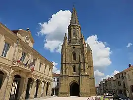 The church and town hall in Boulogne-sur-Gesse | |
.svg.png.webp) Coat of arms | |
Location of Boulogne-sur-Gesse | |
 Boulogne-sur-Gesse  Boulogne-sur-Gesse | |
| Coordinates: 43°17′26″N 0°38′44″E / 43.2906°N 0.6456°E | |
| Country | France |
| Region | Occitania |
| Department | Haute-Garonne |
| Arrondissement | Saint-Gaudens |
| Canton | Saint-Gaudens |
| Government | |
| • Mayor (2020–2026) | Alain Boubée[1] |
| Area 1 | 24.73 km2 (9.55 sq mi) |
| Population | 1,656 |
| • Density | 67/km2 (170/sq mi) |
| Time zone | UTC+01:00 (CET) |
| • Summer (DST) | UTC+02:00 (CEST) |
| INSEE/Postal code | 31080 /31350 |
| Elevation | 243–388 m (797–1,273 ft) (avg. 335 m or 1,099 ft) |
| 1 French Land Register data, which excludes lakes, ponds, glaciers > 1 km2 (0.386 sq mi or 247 acres) and river estuaries. | |
Boulogne-sur-Gesse (French pronunciation: [bulɔɲ syʁ ʒɛs], literally Boulogne on Gesse; Gascon: Bolonha de Gessa) is a commune of the Haute-Garonne department in southwestern France.
Geography
The river Gesse forms most of the commune's eastern border, while the Gimone forms part of its southwestern and northwestern borders.
Population
| Year | Pop. | ±% |
|---|---|---|
| 1962 | 1,777 | — |
| 1968 | 1,865 | +5.0% |
| 1975 | 1,756 | −5.8% |
| 1982 | 1,671 | −4.8% |
| 1990 | 1,531 | −8.4% |
| 1999 | 1,433 | −6.4% |
| 2004 | 1,620 | +13.0% |
| 2009 | 1,612 | −0.5% |
| 2014 | 1,604 | −0.5% |
| 2017 | 1,612 | +0.5% |
See also
References
- ↑ "Répertoire national des élus: les maires". data.gouv.fr, Plateforme ouverte des données publiques françaises (in French). 2 December 2020.
- ↑ "Populations légales 2021". The National Institute of Statistics and Economic Studies. 28 December 2023.
Wikimedia Commons has media related to Boulogne-sur-Gesse.
This article is issued from Wikipedia. The text is licensed under Creative Commons - Attribution - Sharealike. Additional terms may apply for the media files.