Lautignac | |
|---|---|
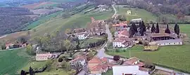 An aerial view of Lautignac | |
Location of Lautignac | |
 Lautignac  Lautignac | |
| Coordinates: 43°22′57″N 1°03′29″E / 43.3825°N 1.0581°E | |
| Country | France |
| Region | Occitania |
| Department | Haute-Garonne |
| Arrondissement | Muret |
| Canton | Cazères |
| Government | |
| • Mayor (2020–2026) | Monique Pellizzer[1] |
| Area 1 | 17.77 km2 (6.86 sq mi) |
| Population | 254 |
| • Density | 14/km2 (37/sq mi) |
| Time zone | UTC+01:00 (CET) |
| • Summer (DST) | UTC+02:00 (CEST) |
| INSEE/Postal code | 31283 /31370 |
| Elevation | 281–351 m (922–1,152 ft) (avg. 310 m or 1,020 ft) |
| 1 French Land Register data, which excludes lakes, ponds, glaciers > 1 km2 (0.386 sq mi or 247 acres) and river estuaries. | |
Lautignac (French pronunciation: [lotiɲak]; Occitan: Lautinhac) is a commune in the Haute-Garonne department in southwestern France.
Population
| Year | Pop. | ±% p.a. |
|---|---|---|
| 1968 | 205 | — |
| 1975 | 171 | −2.56% |
| 1982 | 191 | +1.59% |
| 1990 | 201 | +0.64% |
| 1999 | 218 | +0.91% |
| 2009 | 281 | +2.57% |
| 2014 | 277 | −0.29% |
| 2020 | 260 | −1.05% |
| Source: INSEE[3] | ||
See also
References
- ↑ "Répertoire national des élus: les maires". data.gouv.fr, Plateforme ouverte des données publiques françaises (in French). 9 August 2021.
- ↑ "Populations légales 2021". The National Institute of Statistics and Economic Studies. 28 December 2023.
- ↑ Population en historique depuis 1968, INSEE
Wikimedia Commons has media related to Lautignac.
This article is issued from Wikipedia. The text is licensed under Creative Commons - Attribution - Sharealike. Additional terms may apply for the media files.