Congé-sur-Orne | |
|---|---|
 View of the road to Dangeul | |
Location of Congé-sur-Orne | |
 Congé-sur-Orne  Congé-sur-Orne | |
| Coordinates: 48°12′00″N 0°15′13″E / 48.2°N 0.2536°E | |
| Country | France |
| Region | Pays de la Loire |
| Department | Sarthe |
| Arrondissement | Mamers |
| Canton | Mamers |
| Intercommunality | Maine Saosnois |
| Government | |
| • Mayor (2020–2026) | Katia Ambrois[1] |
| Area 1 | 11.2 km2 (4.3 sq mi) |
| Population | 324 |
| • Density | 29/km2 (75/sq mi) |
| Time zone | UTC+01:00 (CET) |
| • Summer (DST) | UTC+02:00 (CEST) |
| INSEE/Postal code | 72088 /72290 |
| Elevation | 53–73 m (174–240 ft) |
| 1 French Land Register data, which excludes lakes, ponds, glaciers > 1 km2 (0.386 sq mi or 247 acres) and river estuaries. | |
Congé-sur-Orne is a commune in the Sarthe department in the Pays de la Loire region in north-western France.
Its inhabitants are called 'Congéennes' and 'Congéens'; most of its population resides in the village, locally called le bourg; the rest is disseminated in hamlets and in isolated farms.
See also
References
- ↑ "Répertoire national des élus: les maires". data.gouv.fr, Plateforme ouverte des données publiques françaises (in French). 2 December 2020.
- ↑ "Populations légales 2021". The National Institute of Statistics and Economic Studies. 28 December 2023.
Pictures
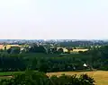 Congé-sur-Orne viewed from the hillsides of Ballon
 Congé-sur-Orne from the road of Dangeul
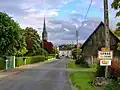 Entering the 'bourg.'
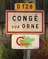
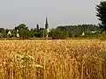
- Congé-sur-Orne from the road of Dangeul
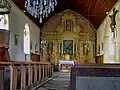 The church
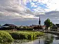 The Orne river
Wikimedia Commons has media related to Congé-sur-Orne.
This article is issued from Wikipedia. The text is licensed under Creative Commons - Attribution - Sharealike. Additional terms may apply for the media files.