Mamers | |
|---|---|
Subprefecture and commune | |
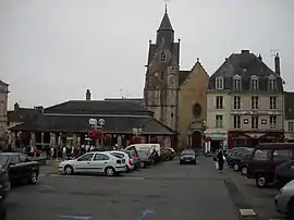 Carnot Square at the town center | |
.svg.png.webp) Coat of arms | |
Location of Mamers | |
 Mamers  Mamers | |
| Coordinates: 48°21′06″N 0°22′04″E / 48.3517°N 0.3678°E | |
| Country | France |
| Region | Pays de la Loire |
| Department | Sarthe |
| Arrondissement | Mamers |
| Canton | Mamers |
| Intercommunality | Maine Saosnois |
| Government | |
| • Mayor (2020–2026) | Frédéric Beauchef[1] |
| Area 1 | 5.05 km2 (1.95 sq mi) |
| Population | 5,103 |
| • Density | 1,000/km2 (2,600/sq mi) |
| Time zone | UTC+01:00 (CET) |
| • Summer (DST) | UTC+02:00 (CEST) |
| INSEE/Postal code | 72180 /72600 |
| 1 French Land Register data, which excludes lakes, ponds, glaciers > 1 km2 (0.386 sq mi or 247 acres) and river estuaries. | |
Mamers (French: [mamɛʁs] ⓘ) is a commune in the Sarthe department in the region of Pays de la Loire in north-western France. The neighboring communes are: Commerveil, Saint-Longis, Saint-Rémy-des-Monts, Origny-le-Roux, Suré. Mamers is twinned with the town Market Rasen in Lincolnshire, England.
Population
| Year | Pop. | ±% p.a. |
|---|---|---|
| 1968 | 5,777 | — |
| 1975 | 6,392 | +1.46% |
| 1982 | 6,450 | +0.13% |
| 1990 | 6,071 | −0.75% |
| 1999 | 6,084 | +0.02% |
| 2007 | 5,679 | −0.86% |
| 2012 | 5,423 | −0.92% |
| 2017 | 5,299 | −0.46% |
| Source: INSEE[3] | ||
See also
References
- ↑ "Répertoire national des élus: les maires" (in French). data.gouv.fr, Plateforme ouverte des données publiques françaises. 13 September 2022.
- ↑ "Populations légales 2021". The National Institute of Statistics and Economic Studies. 28 December 2023.
- ↑ Population en historique depuis 1968, INSEE
Wikimedia Commons has media related to Mamers.
This article is issued from Wikipedia. The text is licensed under Creative Commons - Attribution - Sharealike. Additional terms may apply for the media files.