Châteauvilain | |
|---|---|
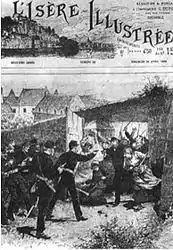 The entrance of the gendarmes into the factory of Châteauvilain. L'Isère Illustrée of 25 April 1886. | |
 Coat of arms | |
Location of Châteauvilain | |
 Châteauvilain  Châteauvilain | |
| Coordinates: 45°31′03″N 5°19′51″E / 45.5175°N 5.3308°E | |
| Country | France |
| Region | Auvergne-Rhône-Alpes |
| Department | Isère |
| Arrondissement | La Tour-du-Pin |
| Canton | Bourgoin-Jallieu |
| Intercommunality | CA Porte de l'Isère |
| Government | |
| • Mayor (2020–2026) | Daniel Gaude[1] |
| Area 1 | 8.82 km2 (3.41 sq mi) |
| Population | 747 |
| • Density | 85/km2 (220/sq mi) |
| Time zone | UTC+01:00 (CET) |
| • Summer (DST) | UTC+02:00 (CEST) |
| INSEE/Postal code | 38091 /38300 |
| Elevation | 345–644 m (1,132–2,113 ft) (avg. 500 m or 1,600 ft) |
| 1 French Land Register data, which excludes lakes, ponds, glaciers > 1 km2 (0.386 sq mi or 247 acres) and river estuaries. | |
Châteauvilain (French pronunciation: [ʃɑtovilɛ̃]) is a commune in the Isère department in south-eastern France.
Population
| Year | Pop. | ±% p.a. |
|---|---|---|
| 1968 | 365 | — |
| 1975 | 355 | −0.40% |
| 1982 | 429 | +2.74% |
| 1990 | 438 | +0.26% |
| 1999 | 483 | +1.09% |
| 2007 | 603 | +2.81% |
| 2012 | 673 | +2.22% |
| 2017 | 716 | +1.25% |
| Source: INSEE[3] | ||
See also
References
- ↑ "Répertoire national des élus: les maires" (in French). data.gouv.fr, Plateforme ouverte des données publiques françaises. 13 September 2022.
- ↑ "Populations légales 2021". The National Institute of Statistics and Economic Studies. 28 December 2023.
- ↑ Population en historique depuis 1968, INSEE
Wikimedia Commons has media related to Châteauvilain.
This article is issued from Wikipedia. The text is licensed under Creative Commons - Attribution - Sharealike. Additional terms may apply for the media files.