Saint-Gervais | |
|---|---|
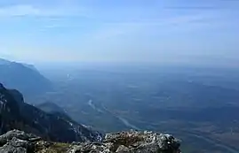 Saint-Gervais and Rovon to the left of the Isère, seen from la Cheminée (Vercors). | |
Location of Saint-Gervais | |
 Saint-Gervais  Saint-Gervais | |
| Coordinates: 45°12′09″N 5°28′58″E / 45.2025°N 5.4828°E | |
| Country | France |
| Region | Auvergne-Rhône-Alpes |
| Department | Isère |
| Arrondissement | Grenoble |
| Canton | Le Sud Grésivaudan |
| Government | |
| • Mayor (2020–2026) | Didier Cheneau[1] |
| Area 1 | 13.15 km2 (5.08 sq mi) |
| Population | 530 |
| • Density | 40/km2 (100/sq mi) |
| Time zone | UTC+01:00 (CET) |
| • Summer (DST) | UTC+02:00 (CEST) |
| INSEE/Postal code | 38390 /38470 |
| Elevation | 178–1,536 m (584–5,039 ft) |
| 1 French Land Register data, which excludes lakes, ponds, glaciers > 1 km2 (0.386 sq mi or 247 acres) and river estuaries. | |
Saint-Gervais (French pronunciation: [sɛ̃ ʒɛʁvɛ] ⓘ) is a commune in the Isère department in southeastern France.[3]
Population
| Year | Pop. | ±% p.a. |
|---|---|---|
| 1968 | 298 | — |
| 1975 | 256 | −2.15% |
| 1982 | 288 | +1.70% |
| 1990 | 295 | +0.30% |
| 1999 | 377 | +2.76% |
| 2009 | 566 | +4.15% |
| 2014 | 558 | −0.28% |
| 2020 | 536 | −0.67% |
| Source: INSEE[4] | ||
See also
References
Wikimedia Commons has media related to Saint-Gervais (Isère).
- ↑ "Répertoire national des élus: les maires". data.gouv.fr, Plateforme ouverte des données publiques françaises (in French). 9 August 2021.
- ↑ "Populations légales 2021". The National Institute of Statistics and Economic Studies. 28 December 2023.
- ↑ INSEE commune file
- ↑ Population en historique depuis 1968, INSEE
This article is issued from Wikipedia. The text is licensed under Creative Commons - Attribution - Sharealike. Additional terms may apply for the media files.