Champagnier | |
|---|---|
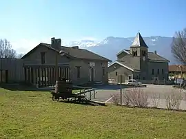 The town hall and church of Champagnier | |
Location of Champagnier | |
 Champagnier  Champagnier | |
| Coordinates: 45°06′38″N 5°43′42″E / 45.1106°N 5.7284°E | |
| Country | France |
| Region | Auvergne-Rhône-Alpes |
| Department | Isère |
| Arrondissement | Grenoble |
| Canton | Le Pont-de-Claix |
| Intercommunality | Grenoble-Alpes Métropole |
| Government | |
| • Mayor (2020–2026) | Florent Cholat[1] |
| Area 1 | 6.61 km2 (2.55 sq mi) |
| Population | 1,406 |
| • Density | 210/km2 (550/sq mi) |
| Time zone | UTC+01:00 (CET) |
| • Summer (DST) | UTC+02:00 (CEST) |
| INSEE/Postal code | 38068 /38800 |
| Elevation | 239–516 m (784–1,693 ft) |
| 1 French Land Register data, which excludes lakes, ponds, glaciers > 1 km2 (0.386 sq mi or 247 acres) and river estuaries. | |
Champagnier (French pronunciation: [ʃɑ̃paɲe]) is a commune in the Isère department in southeastern France.[3]
Population
| Year | Pop. | ±% p.a. |
|---|---|---|
| 1968 | 591 | — |
| 1975 | 641 | +1.17% |
| 1982 | 683 | +0.91% |
| 1990 | 902 | +3.54% |
| 1999 | 961 | +0.71% |
| 2007 | 1,142 | +2.18% |
| 2012 | 1,278 | +2.28% |
| 2017 | 1,226 | −0.83% |
| Source: INSEE[4] | ||
See also
References
- ↑ "Répertoire national des élus: les maires". data.gouv.fr, Plateforme ouverte des données publiques françaises (in French). 2 December 2020.
- ↑ "Populations légales 2021". The National Institute of Statistics and Economic Studies. 28 December 2023.
- ↑ INSEE commune file
- ↑ Population en historique depuis 1968, INSEE
External links
Wikimedia Commons has media related to Champagnier.
This article is issued from Wikipedia. The text is licensed under Creative Commons - Attribution - Sharealike. Additional terms may apply for the media files.