Mont-Saint-Martin | |
|---|---|
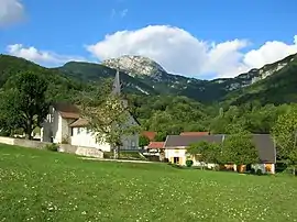 The village of Mont-Saint-Martin | |
Location of Mont-Saint-Martin | |
 Mont-Saint-Martin  Mont-Saint-Martin | |
| Coordinates: 45°16′20″N 5°40′33″E / 45.2722°N 5.6758°E | |
| Country | France |
| Region | Auvergne-Rhône-Alpes |
| Department | Isère |
| Arrondissement | Grenoble |
| Canton | Grenoble-2 |
| Intercommunality | Grenoble-Alpes Métropole |
| Government | |
| • Mayor (2023–2026) | Marc Depinois[1] |
| Area 1 | 5 km2 (2 sq mi) |
| Population | 88 |
| • Density | 18/km2 (46/sq mi) |
| Time zone | UTC+01:00 (CET) |
| • Summer (DST) | UTC+02:00 (CEST) |
| INSEE/Postal code | 38258 /38120 |
| Elevation | 520–1,844 m (1,706–6,050 ft) (avg. 760 m or 2,490 ft) |
| 1 French Land Register data, which excludes lakes, ponds, glaciers > 1 km2 (0.386 sq mi or 247 acres) and river estuaries. | |
Mont-Saint-Martin (French pronunciation: [mɔ̃ sɛ̃ maʁtɛ̃] ⓘ; Arpitan: Mont-Sant-Martin) is a commune in the Isère department in southeastern France.[3]
Population
| Year | Pop. | ±% p.a. |
|---|---|---|
| 1968 | 20 | — |
| 1975 | 45 | +12.28% |
| 1982 | 77 | +7.98% |
| 1990 | 77 | +0.00% |
| 1999 | 98 | +2.72% |
| 2009 | 90 | −0.85% |
| 2014 | 79 | −2.57% |
| 2020 | 83 | +0.83% |
| Source: INSEE[4] | ||
See also
References
- ↑ "Répertoire national des élus: les maires" (in French). data.gouv.fr, Plateforme ouverte des données publiques françaises. 6 June 2023.
- ↑ "Populations légales 2021". The National Institute of Statistics and Economic Studies. 28 December 2023.
- ↑ INSEE commune file
- ↑ Population en historique depuis 1968, INSEE
Wikimedia Commons has media related to Mont-Saint-Martin (Isère).
This article is issued from Wikipedia. The text is licensed under Creative Commons - Attribution - Sharealike. Additional terms may apply for the media files.