Cornillon-sur-l'Oule | |
|---|---|
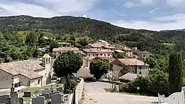 General view of Cornillon-sur-l'Oule | |
 Coat of arms | |
Location of Cornillon-sur-l'Oule | |
 Cornillon-sur-l'Oule  Cornillon-sur-l'Oule | |
| Coordinates: 44°27′34″N 5°22′07″E / 44.4594°N 5.3686°E | |
| Country | France |
| Region | Auvergne-Rhône-Alpes |
| Department | Drôme |
| Arrondissement | Nyons |
| Canton | Nyons et Baronnies |
| Government | |
| • Mayor (2020–2026) | Denis Conil[1] |
| Area 1 | 14.55 km2 (5.62 sq mi) |
| Population | 75 |
| • Density | 5.2/km2 (13/sq mi) |
| Time zone | UTC+01:00 (CET) |
| • Summer (DST) | UTC+02:00 (CEST) |
| INSEE/Postal code | 26105 /26510 |
| Elevation | 470–1,223 m (1,542–4,012 ft) |
| 1 French Land Register data, which excludes lakes, ponds, glaciers > 1 km2 (0.386 sq mi or 247 acres) and river estuaries. | |
Cornillon-sur-l'Oule (French pronunciation: [kɔʁnijɔ̃ syʁ lul]; Occitan: Cornilhon) is a commune in the Drôme department in southeastern France.
Population
| Year | Pop. | ±% p.a. |
|---|---|---|
| 1968 | 86 | — |
| 1975 | 80 | −1.03% |
| 1982 | 75 | −0.92% |
| 1990 | 68 | −1.22% |
| 1999 | 65 | −0.50% |
| 2009 | 72 | +1.03% |
| 2014 | 71 | −0.28% |
| 2020 | 74 | +0.69% |
| Source: INSEE[3] | ||
See also
References
- ↑ "Répertoire national des élus: les maires". data.gouv.fr, Plateforme ouverte des données publiques françaises (in French). 9 August 2021.
- ↑ "Populations légales 2021". The National Institute of Statistics and Economic Studies. 28 December 2023.
- ↑ Population en historique depuis 1968, INSEE
Wikimedia Commons has media related to Cornillon-sur-l'Oule.
This article is issued from Wikipedia. The text is licensed under Creative Commons - Attribution - Sharealike. Additional terms may apply for the media files.