Roussas | |
|---|---|
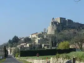 The village of Roussas and its château | |
Location of Roussas | |
 Roussas  Roussas | |
| Coordinates: 44°25′54″N 4°48′09″E / 44.4317°N 4.8025°E | |
| Country | France |
| Region | Auvergne-Rhône-Alpes |
| Department | Drôme |
| Arrondissement | Nyons |
| Canton | Grignan |
| Government | |
| • Mayor (2020–2026) | Christiane Robert[1] |
| Area 1 | 16.07 km2 (6.20 sq mi) |
| Population | 392 |
| • Density | 24/km2 (63/sq mi) |
| Time zone | UTC+01:00 (CET) |
| • Summer (DST) | UTC+02:00 (CEST) |
| INSEE/Postal code | 26284 /26230 |
| Elevation | 83–390 m (272–1,280 ft) (avg. 182 m or 597 ft) |
| 1 French Land Register data, which excludes lakes, ponds, glaciers > 1 km2 (0.386 sq mi or 247 acres) and river estuaries. | |
Roussas is a commune in the Drôme department in southeastern France.
Population
| Year | Pop. | ±% p.a. |
|---|---|---|
| 1968 | 157 | — |
| 1975 | 182 | +2.13% |
| 1982 | 246 | +4.40% |
| 1990 | 315 | +3.14% |
| 1999 | 345 | +1.02% |
| 2009 | 338 | −0.20% |
| 2014 | 364 | +1.49% |
| 2020 | 383 | +0.85% |
| Source: INSEE[3] | ||
See also
References
- ↑ "Répertoire national des élus: les maires". data.gouv.fr, Plateforme ouverte des données publiques françaises (in French). 9 August 2021.
- ↑ "Populations légales 2021". The National Institute of Statistics and Economic Studies. 28 December 2023.
- ↑ Population en historique depuis 1968, INSEE
Wikimedia Commons has media related to Roussas.
This article is issued from Wikipedia. The text is licensed under Creative Commons - Attribution - Sharealike. Additional terms may apply for the media files.