Reilhanette | |
|---|---|
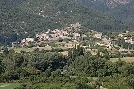 A general view of Reilhanette | |
Location of Reilhanette | |
 Reilhanette  Reilhanette | |
| Coordinates: 44°10′11″N 5°25′15″E / 44.1697°N 5.4208°E | |
| Country | France |
| Region | Auvergne-Rhône-Alpes |
| Department | Drôme |
| Arrondissement | Nyons |
| Canton | Nyons et Baronnies |
| Government | |
| • Mayor (2020–2026) | Martial Bonnefoy[1] |
| Area 1 | 14.78 km2 (5.71 sq mi) |
| Population | 133 |
| • Density | 9.0/km2 (23/sq mi) |
| Time zone | UTC+01:00 (CET) |
| • Summer (DST) | UTC+02:00 (CEST) |
| INSEE/Postal code | 26263 /26570 |
| Elevation | 512–1,313 m (1,680–4,308 ft) (avg. 568 m or 1,864 ft) |
| 1 French Land Register data, which excludes lakes, ponds, glaciers > 1 km2 (0.386 sq mi or 247 acres) and river estuaries. | |
Reilhanette (French pronunciation: [ʁɛjanɛt]) is a commune in the Drôme department in southeastern France.
Population
| Year | Pop. | ±% p.a. |
|---|---|---|
| 1968 | 101 | — |
| 1975 | 103 | +0.28% |
| 1982 | 114 | +1.46% |
| 1990 | 130 | +1.66% |
| 1999 | 119 | −0.98% |
| 2009 | 150 | +2.34% |
| 2014 | 145 | −0.68% |
| 2020 | 146 | +0.11% |
| Source: INSEE[3] | ||
See also
References
- ↑ "Répertoire national des élus: les maires". data.gouv.fr, Plateforme ouverte des données publiques françaises (in French). 9 August 2021.
- ↑ "Populations légales 2021". The National Institute of Statistics and Economic Studies. 28 December 2023.
- ↑ Population en historique depuis 1968, INSEE
Wikimedia Commons has media related to Reilhanette.
This article is issued from Wikipedia. The text is licensed under Creative Commons - Attribution - Sharealike. Additional terms may apply for the media files.