Rémuzat | |
|---|---|
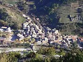 A view of Rémuzat from the nearby hillside | |
 Coat of arms | |
Location of Rémuzat | |
 Rémuzat  Rémuzat | |
| Coordinates: 44°24′51″N 5°21′25″E / 44.4142°N 5.3569°E | |
| Country | France |
| Region | Auvergne-Rhône-Alpes |
| Department | Drôme |
| Arrondissement | Nyons |
| Canton | Nyons et Baronnies |
| Government | |
| • Mayor (2020–2026) | Olivier Salin[1] |
| Area 1 | 16.78 km2 (6.48 sq mi) |
| Population | 315 |
| • Density | 19/km2 (49/sq mi) |
| Time zone | UTC+01:00 (CET) |
| • Summer (DST) | UTC+02:00 (CEST) |
| INSEE/Postal code | 26264 /26510 |
| Elevation | 425–1,201 m (1,394–3,940 ft) |
| 1 French Land Register data, which excludes lakes, ponds, glaciers > 1 km2 (0.386 sq mi or 247 acres) and river estuaries. | |
Rémuzat (French pronunciation: [ʁemyza]; Vivaro-Alpine: Remusat) is a commune in the Drôme department in southeastern France.
Population
| Year | Pop. | ±% p.a. |
|---|---|---|
| 1968 | 301 | — |
| 1975 | 332 | +1.41% |
| 1982 | 364 | +1.32% |
| 1990 | 364 | +0.00% |
| 1999 | 283 | −2.76% |
| 2009 | 319 | +1.20% |
| 2014 | 334 | +0.92% |
| 2020 | 325 | −0.45% |
| Source: INSEE[3] | ||
Sights
- The Rocher du Caire, a large cliff inhabited by griffon vultures.
See also
References
- ↑ "Répertoire national des élus: les maires" (in French). data.gouv.fr, Plateforme ouverte des données publiques françaises. 13 September 2022.
- ↑ "Populations légales 2021". The National Institute of Statistics and Economic Studies. 28 December 2023.
- ↑ Population en historique depuis 1968, INSEE
Wikimedia Commons has media related to Rémuzat.
This article is issued from Wikipedia. The text is licensed under Creative Commons - Attribution - Sharealike. Additional terms may apply for the media files.