Allery | |
|---|---|
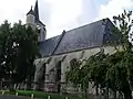
 The church in Allery | |
.svg.png.webp) Coat of arms | |
Location of Allery | |
 Allery  Allery | |
| Coordinates: 49°57′55″N 1°54′03″E / 49.9653°N 1.9008°E | |
| Country | France |
| Region | Hauts-de-France |
| Department | Somme |
| Arrondissement | Abbeville |
| Canton | Gamaches |
| Intercommunality | CC Somme Sud-Ouest |
| Government | |
| • Mayor (2020–2026) | François Quignon[1] |
| Area 1 | 13.07 km2 (5.05 sq mi) |
| Population | 809 |
| • Density | 62/km2 (160/sq mi) |
| Time zone | UTC+01:00 (CET) |
| • Summer (DST) | UTC+02:00 (CEST) |
| INSEE/Postal code | 80019 /80270 |
| Elevation | 28–127 m (92–417 ft) (avg. 28 m or 92 ft) |
| 1 French Land Register data, which excludes lakes, ponds, glaciers > 1 km2 (0.386 sq mi or 247 acres) and river estuaries. | |
Allery (French pronunciation: [alʁi]) is a commune in the Somme department in Hauts-de-France in northern France.
Geography
The commune is situated 25 km (16 mi) south of Abbeville, at the junction of the D193 and D76 roads.
Population
| Year | Pop. | ±% p.a. |
|---|---|---|
| 1968 | 911 | — |
| 1975 | 863 | −0.77% |
| 1982 | 790 | −1.25% |
| 1990 | 736 | −0.88% |
| 1999 | 752 | +0.24% |
| 2007 | 760 | +0.13% |
| 2012 | 806 | +1.18% |
| 2017 | 793 | −0.32% |
| Source: INSEE[3] | ||
Places and monuments
- War Memorial
- twelfth century church
See also
References
- ↑ "Répertoire national des élus: les maires". data.gouv.fr, Plateforme ouverte des données publiques françaises (in French). 9 August 2021.
- ↑ "Populations légales 2021". The National Institute of Statistics and Economic Studies. 28 December 2023.
- ↑ Population en historique depuis 1968, INSEE
Wikimedia Commons has media related to Allery.
 Around the church
 The bell-tower and external staircase
_1.jpg.webp) Fleur de lys decoration on the stained-glass
Fleur de lys decoration on the stained-glass The bell-tower
This article is issued from Wikipedia. The text is licensed under Creative Commons - Attribution - Sharealike. Additional terms may apply for the media files.