Nurlu | |
|---|---|
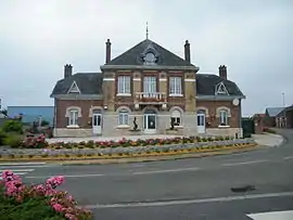 The town hall and school in Nurlu | |
Location of Nurlu | |
 Nurlu  Nurlu | |
| Coordinates: 50°00′27″N 3°01′14″E / 50.0075°N 3.0206°E | |
| Country | France |
| Region | Hauts-de-France |
| Department | Somme |
| Arrondissement | Péronne |
| Canton | Péronne |
| Intercommunality | Haute Somme |
| Government | |
| • Mayor (2020–2026) | Pascal Douay[1] |
| Area 1 | 6.53 km2 (2.52 sq mi) |
| Population | 368 |
| • Density | 56/km2 (150/sq mi) |
| Time zone | UTC+01:00 (CET) |
| • Summer (DST) | UTC+02:00 (CEST) |
| INSEE/Postal code | 80601 /80240 |
| Elevation | 115–154 m (377–505 ft) (avg. 150 m or 490 ft) |
| 1 French Land Register data, which excludes lakes, ponds, glaciers > 1 km2 (0.386 sq mi or 247 acres) and river estuaries. | |
Nurlu (French pronunciation: [nyʁly]) is a commune in the Somme department in Hauts-de-France in northern France.
Geography
Nurlu is situated on the D917 road, some 15 miles (24 km) northwest of Saint-Quentin, in the far south-east of the département.
Population
| Year | Pop. | ±% p.a. |
|---|---|---|
| 1968 | 456 | — |
| 1975 | 410 | −1.51% |
| 1982 | 363 | −1.72% |
| 1990 | 347 | −0.56% |
| 1999 | 378 | +0.96% |
| 2007 | 373 | −0.17% |
| 2012 | 399 | +1.36% |
| 2017 | 387 | −0.61% |
| Source: INSEE[3] | ||
Places of interest
- The church, rebuilt by local architect Louis Faille.
- The Mairie and school, also rebuilt by Faille
- The house of Louis Faille
See also
References
- ↑ "Répertoire national des élus: les maires" (in French). data.gouv.fr, Plateforme ouverte des données publiques françaises. 13 September 2022.
- ↑ "Populations légales 2021". The National Institute of Statistics and Economic Studies. 28 December 2023.
- ↑ Population en historique depuis 1968, INSEE
Wikimedia Commons has media related to Nurlu.
This article is issued from Wikipedia. The text is licensed under Creative Commons - Attribution - Sharealike. Additional terms may apply for the media files.