Naours | |
|---|---|
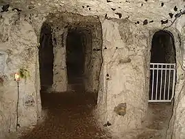 Chapel in the underground city of Naours | |
.svg.png.webp) Coat of arms | |
Location of Naours | |
 Naours  Naours | |
| Coordinates: 50°02′10″N 2°16′39″E / 50.0361°N 2.2775°E | |
| Country | France |
| Region | Hauts-de-France |
| Department | Somme |
| Arrondissement | Amiens |
| Canton | Corbie |
| Intercommunality | CC Territoire Nord Picardie |
| Government | |
| • Mayor (2020–2026) | Jean-Michel Bouchy[1] |
| Area 1 | 16.55 km2 (6.39 sq mi) |
| Population | 1,063 |
| • Density | 64/km2 (170/sq mi) |
| Time zone | UTC+01:00 (CET) |
| • Summer (DST) | UTC+02:00 (CEST) |
| INSEE/Postal code | 80584 /80260 |
| Elevation | 61–154 m (200–505 ft) (avg. 30 m or 98 ft) |
| 1 French Land Register data, which excludes lakes, ponds, glaciers > 1 km2 (0.386 sq mi or 247 acres) and river estuaries. | |
Naours (French pronunciation: [nauʁ]; Picard: Nour) is a commune in the Somme department in Hauts-de-France in northern France.
Geography
Naours is situated on the D117 and D60 crossroads, some 13 miles (21 km) north of Amiens.
Population
| Year | Pop. | ±% p.a. |
|---|---|---|
| 1968 | 683 | — |
| 1975 | 721 | +0.78% |
| 1982 | 962 | +4.21% |
| 1990 | 1,050 | +1.10% |
| 1999 | 1,124 | +0.76% |
| 2007 | 1,141 | +0.19% |
| 2012 | 1,108 | −0.59% |
| 2017 | 1,080 | −0.51% |
| Source: INSEE[3] | ||
See also
References
- ↑ "Répertoire national des élus: les maires". data.gouv.fr, Plateforme ouverte des données publiques françaises (in French). 2 December 2020.
- ↑ "Populations légales 2021". The National Institute of Statistics and Economic Studies. 28 December 2023.
- ↑ Population en historique depuis 1968, INSEE
External links
Wikimedia Commons has media related to Naours.
This article is issued from Wikipedia. The text is licensed under Creative Commons - Attribution - Sharealike. Additional terms may apply for the media files.