Yvrench | |
|---|---|
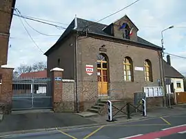 The town hall in Yvrench | |
 Coat of arms | |
Location of Yvrench | |
 Yvrench  Yvrench | |
| Coordinates: 50°10′46″N 2°00′19″E / 50.1794°N 2.0053°E | |
| Country | France |
| Region | Hauts-de-France |
| Department | Somme |
| Arrondissement | Abbeville |
| Canton | Rue |
| Intercommunality | Ponthieu-Marquenterre |
| Government | |
| • Mayor (2020–2026) | Valérie-Anne Canal[1] |
| Area 1 | 9.29 km2 (3.59 sq mi) |
| Population | 301 |
| • Density | 32/km2 (84/sq mi) |
| Time zone | UTC+01:00 (CET) |
| • Summer (DST) | UTC+02:00 (CEST) |
| INSEE/Postal code | 80832 /80150 |
| Elevation | 85–130 m (279–427 ft) (avg. 120 m or 390 ft) |
| 1 French Land Register data, which excludes lakes, ponds, glaciers > 1 km2 (0.386 sq mi or 247 acres) and river estuaries. | |
Yvrench is a commune in the Somme department in Hauts-de-France in northern France.
Geography
Yvrench is situated 9 miles(15 km) northeast of Abbeville, on the D108 road, the route of the old Roman road, the Chaussée Brunehaut.
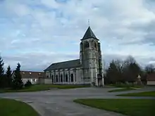
St Martin Church.
Population
|
| ||||||||||||||||||||||||||||||||||||||||||||||||||||||||||||||||||||||||||||||||||||||||||||||||||||||||||||||||||
| Source: EHESS (1793-1999)[3] and INSEE[4] | |||||||||||||||||||||||||||||||||||||||||||||||||||||||||||||||||||||||||||||||||||||||||||||||||||||||||||||||||||
See also
References
- ↑ "Répertoire national des élus: les maires" (in French). data.gouv.fr, Plateforme ouverte des données publiques françaises. 13 September 2022.
- ↑ "Populations légales 2021". The National Institute of Statistics and Economic Studies. 28 December 2023.
- ↑ Des villages de Cassini aux communes d'aujourd'hui: Commune data sheet Yvrench, EHESS (in French).
- ↑ Population en historique depuis 1968, INSEE
Wikimedia Commons has media related to Yvrench.
This article is issued from Wikipedia. The text is licensed under Creative Commons - Attribution - Sharealike. Additional terms may apply for the media files.