Bléquin
Belken | |
|---|---|
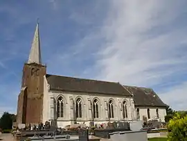 The church of Bléquin | |
 Coat of arms | |
Location of Bléquin | |
 Bléquin  Bléquin | |
| Coordinates: 50°39′51″N 1°59′24″E / 50.6642°N 1.99°E / 50.6642; 1.99 | |
| Country | France |
| Region | Hauts-de-France |
| Department | Pas-de-Calais |
| Arrondissement | Saint-Omer |
| Canton | Lumbres |
| Intercommunality | Pays de Lumbres |
| Government | |
| • Mayor (2020–2026) | Jean Gardin[1] |
| Area 1 | 8.69 km2 (3.36 sq mi) |
| Population | 487 |
| • Density | 56/km2 (150/sq mi) |
| Time zone | UTC+01:00 (CET) |
| • Summer (DST) | UTC+02:00 (CEST) |
| INSEE/Postal code | 62140 /62380 |
| Elevation | 98–208 m (322–682 ft) (avg. 115 m or 377 ft) |
| 1 French Land Register data, which excludes lakes, ponds, glaciers > 1 km2 (0.386 sq mi or 247 acres) and river estuaries. | |
Bléquin (French pronunciation: [blekɛ̃]; West Flemish: Belken) is a commune in the Pas-de-Calais department in the Hauts-de-France region in northern France.[3]
Geography
A village situated 15 miles (24 km) southwest of Saint-Omer, on theD202 road.
Population
| Year | Pop. | ±% |
|---|---|---|
| 1962 | 429 | — |
| 1968 | 471 | +9.8% |
| 1975 | 395 | −16.1% |
| 1982 | 363 | −8.1% |
| 1990 | 368 | +1.4% |
| 1999 | 339 | −7.9% |
| 2009 | 404 | +19.2% |
Sights
- The nineteenth-century church of St. Omer.
- The ruins of a 13th-century chateau.
See also
References
- ↑ "Répertoire national des élus: les maires". data.gouv.fr, Plateforme ouverte des données publiques françaises (in French). 9 August 2021.
- ↑ "Populations légales 2021". The National Institute of Statistics and Economic Studies. 28 December 2023.
- ↑ INSEE commune file
Wikimedia Commons has media related to Bléquin.
This article is issued from Wikipedia. The text is licensed under Creative Commons - Attribution - Sharealike. Additional terms may apply for the media files.