Manin
Manning | |
|---|---|
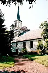 The church of Manin | |
 Coat of arms | |
Location of Manin | |
 Manin  Manin | |
| Coordinates: 50°17′54″N 2°30′43″E / 50.2983°N 2.5119°E | |
| Country | France |
| Region | Hauts-de-France |
| Department | Pas-de-Calais |
| Arrondissement | Arras |
| Canton | Avesnes-le-Comte |
| Intercommunality | CC Campagnes de l'Artois |
| Government | |
| • Mayor (2020–2026) | Philippe Duez[1] |
| Area 1 | 4.07 km2 (1.57 sq mi) |
| Population | 181 |
| • Density | 44/km2 (120/sq mi) |
| Time zone | UTC+01:00 (CET) |
| • Summer (DST) | UTC+02:00 (CEST) |
| INSEE/Postal code | 62544 /62810 |
| Elevation | 113–152 m (371–499 ft) (avg. 125 m or 410 ft) |
| 1 French Land Register data, which excludes lakes, ponds, glaciers > 1 km2 (0.386 sq mi or 247 acres) and river estuaries. | |
Manin (French pronunciation: [manɛ̃]; West Flemish: Manning) is a commune in the Pas-de-Calais department in the Hauts-de-France region of France.[3]
Geography
Manin is situated 15 miles (24 km) west of Arras, at the junction of the D8 and the D78 roads.
Population
| Year | Pop. | ±% p.a. |
|---|---|---|
| 1968 | 149 | — |
| 1975 | 146 | −0.29% |
| 1982 | 151 | +0.48% |
| 1990 | 158 | +0.57% |
| 1999 | 178 | +1.33% |
| 2007 | 189 | +0.75% |
| 2012 | 197 | +0.83% |
| 2017 | 185 | −1.25% |
| Source: INSEE[4] | ||
Places of interest
- The church of St.Maclou, dating from the eighteenth century.
- An eighteenth-century chateau.
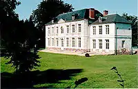
The château at Manin
See also
References
- ↑ "Répertoire national des élus: les maires". data.gouv.fr, Plateforme ouverte des données publiques françaises (in French). 9 August 2021.
- ↑ "Populations légales 2021". The National Institute of Statistics and Economic Studies. 28 December 2023.
- ↑ INSEE commune file
- ↑ Population en historique depuis 1968, INSEE
Wikimedia Commons has media related to Manin.
This article is issued from Wikipedia. The text is licensed under Creative Commons - Attribution - Sharealike. Additional terms may apply for the media files.